Note: Descriptions are shown in the official language in which they were submitted.
CA 02834926 2013-11-01
WO 2012/040828 PCT/CA2011/001093
SATELLITE SYSTEM AND METHOD FOR CIRCUMPOLAR LATITUDES
FIELD OF INVENTION
[0001] The present invention relates to satellite systems and more
particularly, to the provision of
a satellite system and method for weather and climate monitoring,
communications applications,
scientific research and similar tasks at higher latitudes, in either the
northern hemisphere or the
southern hemisphere.
BACKGROUND OF THE INVENTION
[0002] Meteorological monitoring satellites and communications satellites are
usually located in
Geostationary Earth Orbit ¨ (GEO) or Low Earth Orbit (LEO). GEO satellites
appear to be
motionless in the sky, providing the satellite with a continuous view of a
given area on the surface
of the Earth. Unfortunately, such an orbit can only be obtained by placing the
satellite directly
above the Earth's equator (0 latitude), with a period equal to the Earth's
rotational period, an
orbital eccentricity of approximately zero and at an altitude of 35,789 km.
While such orbits are
useful in many applications, they are very poor at covering higher latitudes
(not very useful above
60 latitude for weather and climate monitoring nor above 70 latitude for
reliable mobile
communications). The optical sensors on a GEO meteorological monitoring
satellite, for
example, would view higher latitudes at such a poor angle (i.e. a low
"elevation angle") that it
could not collect useful data. GEO communications satellite links become
unreliable or fail as the
elevation angle to the satellite decreases with increasing latitude.
[0003] Low Earth Orbit (LEO) satellites are placed in circular orbits at low
altitudes (less than
2,000 km) and can provide continuous coverage of the circumpolar region but
this requires many
satellites as each one is over the region for a relatively small amount of
time. One operational
example is the Iridium system which uses a constellation of 66 satellites.
While practical for
relatively low bandwidth communications, it is not cost effective for
broadband communications
or for weather and climate monitoring which require large and expensive
payloads to be placed on
each satellite. In view of the cost of building, launching and maintaining
each satellite this is a
very expensive way of providing continuous satellite coverage of a specific
geographic area.
- -
CA 02834926 2013-11-01
WO 2012/040828 PCT/CA2011/001093
[0004] Highly Elliptical Orbits (HEO) such as the Molniya and the classic
Tundra orbits can
provide better converge of high latitudes with fewer satellites, but both
orbits are problematic.
[0005] Highly Elliptical Orbits (HEO) are those in which one of the foci of
the orbit is the centre
of the Earth. The speed of a satellite in an elliptical orbit is a declining
function of the distance
from the focus. Arranging the satellite to travel close to the Earth during
one part of its orbit (the
perigee) will cause it to travel very quickly at that time, while at the other
end of the orbit (the
apogee), it will travel very slowly. A satellite placed in these orbits spends
most of its time over a
chosen area of the Earth, a phenomenon known as "apogee dwell". The satellite
moves relatively
slowly over the areas of interest, and quickly over areas that are not of
interest.
[0006] The orbital plane of a HEO is inclined with respect to the Earth's
equator. An inclination
close to 63.40 is chosen in order to minimize the requirement for the
satellite on-board propulsion
system to maintain the apogee above the service area.
[0007] The Molniya orbit is a HEO with an orbital period of approximately 12
hours. The
altitude at the perigee of a Molniya orbit is low (on the order of 500 km
above the Earth's surface)
and the orbit passes through the Van Allen Belts. The Van Allen Belts are
belts of energetic
charged particles (plasma) around the Earth, which are held in place by
Earth's magnetic field.
Solar cells, integrated circuits and sensors are damaged by the radiation
levels in these belts, even
if they are "hardened" or other safety measures are implemented, for example,
turning sensors off
when passing through regions of intense radiation. Despite these efforts,
satellites which may
otherwise have a 15 year expected life will only have about a 5 year life if
they have to travel
regularly through the inner Van Allen belt of high energy protons (the outer
belt of electrons is
less problematic). This shortened life of satellites makes Molniya systems
very expensive.
[0008] The classic Tundra orbit is also a Highly Elliptical Orbit, with the
same inclination as
Molniya (63.4'). It is also a geosynchronous orbit with an orbital period of
one sidereal day
(approximately 24 hours). The only operational system in Tundra orbit is
Sirius Satellite Radio,
which operates a constellation of three satellites in different planes, each
satellite plane being
- 2 -
CA 02834926 2013-11-01
WO 2012/040828 PCT/CA2011/001093
offset by 1200, to provide the coverage they desire for their broadcast radio
system. Two satellites
in a classic Tundra orbit could not provide continuous coverage of a
circumpolar region.
[0009] Even in view of the problems with the Molniya (short design life) and
the classic Tundra
systems (requiring more than two satellites for circumpolar coverage), the
experts in the field
support the use of these systems in such applications. For example:
= A current NASA paper ("The case for launching a meteorological imager in
a Molniya
orbit" by Lars Peter Riishojgaard, Global Modeling and Assimilation Office),
asserts that the
most effective way of providing a satellite system for meteorological
monitoring at higher
latitudes, is to use a Molniya system:
http ://wwwwrno.int/pages/prog/www/OSY/Meetings/ODRRGOS-7/Doc7-5( 1 ).pdf
= A European Space Agency paper ("HEO for ATM; SATCOM for AIR TRAFFIC
MANAGEMENT by HEO satellites", Final Report, 2007) concludes that a Tundra
orbit would
take more satellites than Molniya, for coverage of northern latitudes for Air
Traffic Management
(ATM) applications; and
= A presentation at International Communications, Navigations and
Surveillance
Conference, 2009, "SATCOM for ATM in High Latitudes', Jan Erik Hakegard, Trond
Bakken,
Tor Andre Myrvoll, concludes that three satellites in Tundra orbit would be
required for ATM at
high latitudes. See:
http ://i-cns.org/medi a/2009/05/presentation s/Sessi on K Comm un i cati
ons_FCS/01 -H akegard.pdf
[0010] There is therefore a need for an improved satellite system and methods
for providing
coverage of high latitudes, particularly for meteorological monitoring and
communications
applications.
SUMMARY OF THE INVENTION
[0011] It is an object of the invention to provide an improved satellite
system and methods for
providing continuous coverage of the circumpolar region, which mitigates upon
the problems
described above.
- 3 -
CA 2834926 2017-03-06
[0012] Contrary to the teachings in the art it has been determined that a
satellite system and
method may be provided using satellites in 24 sidereal hour orbits
(geosynchronous) with
inclinations, orbital planes, right ascensions and eccentricities chosen to
optimize coverage of a
particular service area located at high latitudes. A constellation of two
satellites can provide
continuous coverage of the circumpolar region. The satellites orbits avoid the
inner Van Allen
belt of high energy protons and can achieve a design life of 15 years or
greater.
[0013] In one embodiment of the invention there is provided a satellite system
for Earth
observation and communications, comprising: a constellation of two satellites,
which together
provide continuous coverage of approximately 20 elevation or greater
throughout a geographic
service area above 60 latitude; each satellite having an orbital inclination
approximately between
70 and 90 and an orbital eccentricity approximately between 0.275 and 0.45;
and a base station
for transmitting to, and receiving signals from, said constellation of two
satellites.
[0014] In another embodiment of the invention there is provided a method of
operation for a
satellite system for Earth observation and communications, comprising:
providing a constellation
of two satellites, which together provide continuous coverage of approximately
20 elevation or
greater throughout a geographic service area above 60 latitude, each
satellite having an orbital
inclination approximately between 70 and 90 and an orbital eccentricity
approximately between
0.275 and 0.45; and providing a base station for transmitting to and receiving
signals from said
constellation of two satellites.
[0015] In a further embodiment of the invention there is provided a satellite
base station,
comprising: communication means for transmitting and receiving signals to and
from a
constellation of two satellites, which together provide continuous coverage of
approximately 20
elevation or greater throughout a geographic service area above approximately
60 latitude; and
flight control means for controlling orbits of said constellation of two
satellites, each satellite
having an orbital inclination approximately between 70 and 90 and an orbital
eccentricity
approximately between 0.275 and 0.45.
- 4 -
CA 02834926 2013-11-01
WO 2012/040828 PCT/CA2011/001093
[0016] In a still further embodiment of the invention there is provided a
satellite comprising:
communication means for transmitting and receiving signals to and from a base
station; an Earth
observation and communications payload for serving a geographic service area
above 600 latitude,
with an elevation of approximately 20 or greater; and flight control means
for controlling an orbit
to have an orbital inclination approximately between 70 and 90 and an
orbital eccentricity
approximately between 0.275 and 0.45.
[0017] Other aspects and features of the present invention will be apparent to
those of ordinary
skill in the art from a review of the following detailed description when
considered in conjunction
with the drawings.
BRIEF DESCRIPTION OF THE DRAWINGS
[0018] These and other features of the invention will become more apparent
from the following
description in which reference is made to the appended drawings wherein:
Figure 1 presents a map of the geographic area to be covered, in this example
for the northern
hemisphere, the area above 60 north.
Figure 2 shows the output plot of a satellite orbit software tool, indicating
the percentage of time
the criterion of a minimum 20 elevation angle is met throughout the area. In
this example the
northern hemisphere above a latitude of 50 north is shown to have slightly
less than 100 percent
coverage. The graph of per cent coverage of the area above 60 indicates 100
per cent coverage.
Figure 3 shows two satellites in an exemplary 24 hour elliptical orbit,
inclined 90 . The satellites
are in the some plane separated by approximately 12 hours.
Figure 4 is a simplified diagram of the Van Allen radiation belts, indicating
the inner proton belt
and the outer electron belt.
Figure 5 depicts the ground trace of two satellites in the same orbital plane,
in an embodiment of
the invention. The ground trace is repeated daily.
- 5 -
CA 02834926 2013-11-01
WO 2012/040828 PCT/CA2011/001093
Figure 6 presents an exemplary network architecture for implementing the
invention.
Figures 7 and 8 are graphs which show the Total Ionizing Dose (TID) for the
orbit of the
invention to be less than those of geostationary and Molniya orbits.
Figure 9 presents an exemplary payload arrangement for a launch vehicle.
Figure 10 presents a flow chart of an exemplary method of implementing the
invention.
Figure 11 presents a block diagram of an exemplary Gateway in an embodiment of
the invention.
Figure 12 presents a block diagram of an exemplary satellite in an embodiment
of the invention.
[0019] Similar reference numerals have been used in different figures to
denote similar
components.
DETAILED DESCRIPTION
[0020] Contrary to the teachings in the art it has been determined that a
satellite system and
method may be provided using satellites in 24 sidereal hour orbits
(geosynchronous) with
inclinations, orbital planes, right ascensions and eccentricities chosen to
optimize coverage of a
particular service area located at high latitudes. A constellation of two
satellites can provide
continuous coverage of the circumpolar region, which is defined as the area
with greater than 60
latitude in either the northern or southern hemispheres (see Figure 1, which
identifies the 60
latitude area of the northern hemisphere). The satellites in this orbit avoid
the inner Van Allen
belt of high energy protons.
[0021] For example, as shown in Figure 2, a constellation of two satellites at
a 90 inclination
and 0.3 eccentricity, will provide a minimum 20 elevation angle for the
entire area above 50
North. for much of the time, with the percentage area coverage at a minimum 20
elevation angle
never less than 96.5%. The "elevation angle" refers to the line-of-sight angle
between the ground
and the satellite as measured from the horizon. The minimum elevation angle
that weather and
- 6 -
CA 02834926 2013-11-01
WO 2012/040828 PCT/CA2011/001093
climate monitoring instruments must have for accurate data is typically in the
vicinity of 200
.
Other exemplary embodiments of the invention are described hereinafter.
[0022] The classic Tundra system does not provide continuous coverage of the
circumpolar
region. By increasing the eccentricity, causing a higher apogee, the coverage
requirement may be
met. However, greater altitude above the coverage area requires larger
antennas and sensors on
the satellite. More importantly, the perigee is lowered causing the satellites
to pass through a
greater portion of the Van Allen belts, reducing their operational life. It is
only by modifying both
the eccentricity and the inclination, that one is able to provide the desired
circumpolar region
coverage at a reasonable altitude, with minimal exposure to the Van Allen
belts. Other
parameters of the system are as follows:
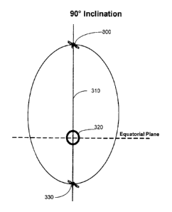
[0023] Inclination: The inclination is the angle between the orbital plane of
the satellites, and the
plane that passes through the Earth's equator. The inclination may only be
slightly greater than
63.4 in some embodiments but is between 80 and 90 for most applications
requiring
circumpolar coverage. Figure 3 shows a simplified diagram of two satellites,
180 apart, in a
HEO orbit with an inclination of 90 . One satellite 300 is at the apogee of
the orbit, passing
through the axis 310 of the Earth 320 in the northern hemisphere, while the
second satellite 330 is
at the perigee, passing through the axis 310 in the southern hemisphere.
[0024] Eccentricity: The eccentricity is the shape of the elliptical path of
the satellites, which
dictates the altitude of the apogee (the highest altitude) and the perigee
(the lowest altitude). The
eccentricity is chosen to have a sufficiently high apogee over the service
area so the satellites are
able to provide the necessary coverage for the required period of its orbit.
Higher eccentricity
increases the altitude of the apogee, which must be overcome with greater
power, antenna gain or
larger optics on the satellite. Higher eccentricities (above approximately
0.34), also increase
exposure to the Van Allen belts.
[0025] Altitude: It is desirable to have as low an apogee as possible above
the coverage area as
increased range negatively impacts the required power and/or sensitivity of
the satellite
instruments. At the perigee of course, a sufficiently high altitude must be
achieved to minimize
- 7 -
CA 02834926 2013-11-01
WO 2012/040828 PCT/CA2011/001093
exposure to the Van Allen Belts. As shown in Figure 4, the Van Allen belts
comprise a torus of
fields around the Earth 320. The belts of greatest concern are the inner belts
of charged protons
410. As will be explained, the outer belts of electrons 420 are of less
concern.
[0026] Place/Number of Satellites: One orbital plane with two or more
satellites is the preferred
implementation. This allows for multiple satellites launched from a single
launch vehicle, or
increasing the number of satellites in the same plane for redundancy and/or
improved
performance. For example, while only two satellites are required, it may be
desirable to launch a
redundant third satellite in case one satellite fails. Because all three
satellites are in the same
plane, it is easier to place into proper position and activate the third
satellite when required. This
kind of redundancy cannot be done in systems which use different orbital
planes for their
satellites.
[0027] Argument of Perigee: The Argument of Perigee describes the orientation
of an elliptical
orbit with respect to the equatorial plane of the Earth. For service to the
north circumpolar region
(e.g. latitudes greater than 60 North), the argument of the perigee is in the
vicinity of 270 so that
the apogee is in the northern hemisphere and the perigee is in the southern
hemisphere. For
service to the south circumpolar region (e.g. latitudes greater than 60
South), the argument of the
perigee is in the vicinity of 90 so that the apogee is in the southern
hemisphere and the perigee is
in the northern hemisphere.
[0028] Longitude of the Ascending Node: In simple terms, the Longitude of the
Ascending Node
describes where the orbital plane crosses the Earth's equator. The Longitude
of the Ascending
Node becomes a factor in specifying the orbit if one wants to bias the
coverage towards a subset
of the circumpolar region, or to optimize a satellite's observation of the
Earth for a situation with
better sunlight illumination, as examples.
[0029] Orbital Period: The orbital period is preferably approximately 24
hours, but this orbit can
be adjusted to provide the required coverage at periods above and below 24
hours and still
achieve continuous coverage of the circumpolar region.
- 8 -
CA 02834926 2013-11-01
WO 2012/040828 PCT/CA2011/001093
[0030] Ground Trace: In the preferred embodiment the two satellites are in the
same orbital plane
and each repeatedly follow a different ground trace. For a two satellite
constellation, the phasing,
or spacing of the satellites in the orbital plane is such that the time
between their respective
apogees is approximately one half the orbital period. See Figure 5 which shows
the ground
traces for an exemplary embodiment of two satellites in the same plane, with
an inclination of 90
and an eccentricity of 0.3.
[0031] Orbit Control: Satellite constellations of the invention experience
changes in the
aforementioned orbital parameters over time due the Earth's oblateness,
gravitational forces of the
sun and moon, and solar radiation pressure. These can be compensated by the
satellite's on-board
propulsion system. The manner is which this is done, is described hereinafter.
[0032] Base Stations: As shown in Figure 6, the system includes a ground based
communications
network 620, satellites 300, 330 with communications functionality, Earth
observation and or
science payloads, and at least one base station or Gateway 610. The base
station or Gateway 610
is required to obtain data from the satellites 300, 330 and to effect
Telemetry, Tracking & Control
(TTC). Directional antennas would be used because of their greater efficiency,
requiring the base
station(s) 610 to track the satellites 300, 330 across the sky. Tracking
technology is well known
in the art, though it would have to be modified to accommodate the two
satellite system of the
invention. Handoff from one satellite to the next as they move across the sky,
would not require
any interaction for the user. Handoff can be affected using known techniques,
though they would
have to be optimized for this implementation.
[0033] Real time two-way communications is possible only when the satellite is
mutually visible
to both a Gateway 610 and an element of the ground based communication network
620. This
network 620 consists of the fixed and mobile satellite terminals which
communicate to the
satellite. Downloading of data generated by the satellite payloads is possible
only when the
satellite is visible to a Gateway 610. It is feasible to increase the number
of strategically placed
Gateways 610 to achieve continuous links between a satellite 300, 330 and at
least one Gateway
610. The satellites 300, 330 may also have "store and forward" functionality
allowing the
satellite to store SOE and other data when communications to a Gateway
infrastructure is not
- 9 -
CA 02834926 2013-11-01
WO 2012/040828 PCT/CA2011/001093
possible. The stored data can then be relayed to the ground segment when
communications is
possible between the satellite and the Gateway.
[0034] Avoiding a large part of the Van Allen belts increases the design life
of the satellites. By
using this invention less frequent launches are required to replenish the
satellite constellation and
there are fewer restrictions in the design and operation of the
communications, Earth observation
and science payloads.
[0035] The flight dynamics (i.e. adjustments required to keep the satellite in
the desired orbit) of
the satellites in such a system would be different from those of other
satellite systems, but the way
in which these problems are handled would be much the same. That is, the
flight path of the
satellite could be disturbed, for example, by the gravitational pull of the
moon and sun, solar
radiation pressure and oblateness of the Earth. Computer software systems are
known to manage
other satellite flight systems and could easily be modified to accommodate the
orbits described
herein.
[0036] It is intended that the system initially be used in a two-way
communication mode, in these
satellite bands: L- Band (1-3 GHz); X band (approximately 7 ¨ 8 GHz); Ku Band
(approximately
11 ¨ 15 GHz), and Ka Band (approximately 17 ¨ 31 GHz). Error correction,
encoding and re-
transmission of lost / corrupted packets would also be used.
[0037] Advantages of the system include at least the following:
= only two satellites are required, in contrast to three required by the
classic Tundra systems,
and many more required by LEO systems for full circumpolar coverage;
= this system minimizes exposure to the Van Allen Belts, giving satellites
a minimum 15
year life rather than the 5 year satellite life expected in a Molniya system;
= the necessary continuous coverage of the circumpolar region for Earth
observation and
broadband communications can be provided, in contrast to GEO systems which
cannot provide
such coverage; and
= the altitude at perigee would be approximately 24,000 km, and non-
continuous
communications and Earth observation are possible at the other circumpolar
region.
-10-
CA 02834926 2013-11-01
WO 2012/040828
PCT/CA2011/001093
Various Embodiments
[0038] The main drivers for this invention can be summarized as follows:
= Applications Science and Earth Observation (SEO) and
Communication/Broadcast
(COM)
= Area of coverage required by the SEO and/or COM) payload
= Minimum elevation angle required by the SEO and/or the COM payload
= Percent of time coverage required from the SEO and COM payload
[0039] As shown in Table 1, the parameters for some exemplary embodiments of
the invention
would be as follows:
TABLE 1 ¨ APPLICATIONS OF THE INVENTION
Main Sub Sub Sub Sub Sub
Application Application Application Application Application Application
-1 _ -2 -3 -4 -5
Application SEO & COM SE0 & COM SEO & SEO &
COM COM COM COM
Coverage
Main N. Pole N. Pole S. Pole S. Pole N. Pole N.
Pole
Secondary S. Pole S. Pole N. Pole N. Pole S. Pole S.
Pole
Sat & Orbits
Satellites 2 2 _ 2 2 2 2
Orbits 1 1 1 1 1 I
Inclination 90 90 900 90 80 -90 70 -90
Eccentricity 0.3 0.275 0.3 0.275 0.3 ¨0.34 0.3
¨0.45
Design life 15 yrs 15 yrs 15 yrs 15 yrs 15 yrs 15 yrs
N-Pole SEO
Area 100% 100% 100%
Coverage>60 N
Min SEO El 20 20 20
Time Coverage 24 hrs 24 hrs 24 hrs
S-Pole SEO
Area 100%
Coverage>60 N
-11-
CA 02834926 2013-11-01
WO 2012/040828
PCT/CA2011/001093
MM SE0 El 20
Time Coverage 24 hrs
N-Pole COM
Area 100% 100% 100% 100%
Coverage>70 N
Time Coverage 24 hrs 24 hrs 24 his 24 hrs
Min Terminal. El 10 10' 10 10
Min Gateway El 50 5 5 50
S-Pole COM
Area 100% 100%
Coverage>70 S
Time Coverage 24 hrs 24 hrs
Min Terminal. El 10 10
Min Gateway El 5 5
[0040] Sub-Application I is for satellites for "communication only" services
to the two Polar
regions. Note that the eccentricity in this application has been relaxed from
0.3 to 0.275. This is
allowable because the COM application can accommodate a lower elevation angle
than the SE0
application. Advantages of the parameters for this embodiment include the
following:
o With a satellite dedicated to communications only (i.e. no SE0 payload),
a larger
communications payload would be possible, allowing, as examples: greater
capacity,
redundancy, larger antennas or more frequency bands;
o The size of the satellite may be reduced, decreasing total costs;
o Possibility of a single launch for multiple satellites; and
o Possibility of carrying more fuel hence longer satellite life cycle
[0041] Sub-Application 2 is the same as the Main application except that the
apogee is placed
over the South Pole which becomes the main service area.
[0042] Sub-Application 3 is the same as Sub Application 1 except that the
apogee is placed over
the South Pole which becomes the main service area. Of course, this
application has the same
advantages as Sub-Application 1.
[0043] While an inclination of 90 has been found to be advantageous, this
parameter can be
relaxed to an inclination range approximately from 70 to 90 as shown in Sub-
Applications 4
-12-
CA 02834926 2013-11-01
WO 2012/040828 PCT/CA2011/001093
and 5. Even with the relaxation of this parameter, this application still
provides the following
advantages:
o Coverage of entire circumpolar region above 600 is possible but the
apogee must increase
with decreasing inclination; e.g., an increase in apogee from 48,100 km to
50,100 km
results from a decrease in inclination from 90 to 80 . Although 2,000 km is a
small
percentage difference, it is significant enough to make the 900 orbit
preferable. The closer
altitude will result in more accurate scientific data and better resolution
from Earth
observation equipment; and
o Satellites not inclined 90 can operate in different orbital planes
making possible a single
ground track.
[0044] Table 2 below, shows the minimum eccentricity (i.e. minimum apogee
height) required to
meet the circumpolar coverage requirement indicated for a range of orbit plane
inclinations under
Sub-Applications 4 and 5, and lower inclinations in general.
[0045] For this table, the circumpolar coverage requirement is defined as 100%
of coverage for
100% of the time of the circumpolar region above 60 north (or below 60 south
for the south
circumpolar region) at a minimum elevation angle of 20 (equivalent to a
maximum angle of
incidence of 70 ).
TABLE 2¨ ANALYSIS OF HIGH INCLINATIONS
Inclination Eccentricity Apogee Height
900 0.30 48435.2 km
87 0.31 48856.8 km
84 0.33 49700.1 km
81 0.34 50121.8km
78 0.36 50965 km
750 0.40 52651.6 km
72 0.42 53494.9 km
690 0.46 55181.4 km
-13-
CA 02834926 2013-11-01
WO 2012/040828 PCT/CA2011/001093
[0046] Lowering the inclination increases the required eccentricity. However,
this results in an
apogee height which will increase the path loss for a communications payload
and reduce the
resolution achieved by an Earth observation payload. Hence, for such
applications, the range of
approximately 80 to 900 inclination is preferred.
[0047] Increasing the eccentricity above a minimum required for a given
inclination will increase
the area which can be continuously covered, in this case to below the 60
latitude contour.
Orbit Control
[0048] Satellite constellations of this invention will experience changes in
the aforementioned
orbital parameters over time due to the Earth's oblateness, gravitational
forces of the sun and
moon, and solar radiation pressure. These can be compensated by performing
periodic orbit-
correction maneuvers using the satellite's on-board propulsion system. The
primary parameter of
concern is the Argument of Perigee.
[0049] For orbit inclinations greater than 63.40, the argument of perigee will
tend to change
(decrease) at a fairly constant rate, due (primarily) to the Earth's
oblateness. As the inclination
increases from 63.4 to 90 , the rate of change of argument of perigee (co)
increases. To maintain
service to the northern polar cap, the orbit apogee must be kept close to the
most northerly point
of the ground track (corresponding to co = 270 ); hence "stationkeeping"
maneuvers will be
performed to control the argument of perigee. These maneuvers will be similar
to the double-
burn east-west maneuvers that are performed to control the eccentricity of a
geostationary
satellite, but will be considerably larger.
[0050] The rate at which the argument of perigee changes is a complex function
of the orbit
inclination, eccentricity, semi-major axis and right ascension of ascending
node (RAAN). Note
that the classic Molniya orbit with an inclination of 63.4 is not exempt from
argument of perigee
changes due to the gravitational effects of the sun and moon; the Molniya
argument of perigee
may decrease by as much as 2 /year, depending on the RAAN. For the orbit of
the invention the
-14-
CA 02834926 2013-11-01
WO 2012/040828 PCT/CA2011/001093
magnitude of the argument of perigee rate is larger. At an inclination of
63.40 the rate may
exceed 6 /year, and at an inclination of 90 the rate is 8.3 /year.
[0051] A single correction to the argument of perigee may be applied by
performing two "delta-
v" maneuvers at opposite sides of the orbit roughly midway between the apogee
and perigee
("delta-v" is merely an aerospace term for a change in velocity). With the
maneuver that is
performed as the satellite moves southward toward perigee, thrusters will be
fired to provide a
retrograde delta-v to reduce the orbit velocity, causing the argument of
perigee to increase. With
the maneuver that is performed as the satellite moves northward toward apogee,
thrusters will be
fired to provide a prograde delta-v to increase the orbit velocity, which will
also increase the
argument of perigee. The two maneuvers will be performed one half-orbit apart;
the order in
which the maneuvers are performed will not matter. The velocity changes of the
two maneuvers
will be roughly equal to avoid unwanted changes to the orbit period.
[0052] The size of each argument of perigee correction will be determined by
the thrust and
duration of the two maneuvers. Because longer maneuvers are less efficient, it
will be preferable
to perform frequent, short-duration maneuvers rather than less-frequent, long-
duration maneuvers.
For satellites equipped with chemical (bi-propellant) propulsion systems, the
achievable thrust
will be large enough to allow several days or even weeks between maneuver
pairs. For satellites
utilizing high-efficiency, low-thrust ion thrusters, maneuvers may be
performed during every orbit
revolution.
[0053] Overtime, if left uncontrolled the other orbit parameters will begin to
wander away from
their nominal values due to the perturbing forces of Earth oblateness and
lunar/solar gravity. The
two remaining "in-plane" classic orbital elements, semi-major axis and
eccentricity, will tend to
move quite slowly and erratically, and may be controlled with virtually zero
additional propellant
by slightly adjusting the locations and difference in magnitudes of the double-
bum maneuvers that
are performed to control the argument of perigee.
[0054] Of the two "out-of-plane" classic elements, the inclination will also
tend to change quite
slowly, and because it is not a critical parameter it will not need to be
controlled. The RAAN,
-15-
CA 02834926 2013-11-01
WO 2012/040828 PCT/CA2011/001093
like the argument of perigee, will tend to change at a fairly constant rate,
resulting in a slow but
steady precession of the orbit plane about the North Pole. The sign and
magnitude of the RAAN
rate will determined by the inclination and initial RAAN value. For the
preferred configuration
with two or more satellites in the same orbit plane, the precession of the
orbit plane will not affect
the coverage of the polar region, so no maneuvers will be required to control
the RAAN. (Note
that the effect of a small, constant rate in the RAAN on the coverage at any
point on the ground
can be easily compensated for by slightly offsetting the average orbit period
from exactly one
sidereal day to maintain a fixed ground track.) For a constellation in which
satellites are
maintained in two or more orbit planes, infrequent "cross-track" maneuvers may
be performed at
the orbit apogees to maintain the nodal separation between planes.
Radiation
[0055] Orbits selected for this invention allow the satellites to avoid the
inner Van Allen radiation
belt of high energy protons. The satellites in this orbit will still pass
through the less severe outer
radiation belt of electrons. Proton particles are much heavier than electron
particles thus they can
create much more damage. It is difficult if not impossible to shield against
high energy protons.
[0056] As the satellite passes through these radiation zones, there is a
cumulative radiation
absorption by the satellite components. This accumulative absorption is one
factor in determining
the design life of a satellite. The second factor, which occurs as a result of
the proton belt but not
the electron belt is called the Single Event Effect (SEE) caused by a single
energetic particle. The
particle can cause a temporary upset in the electronics or permanent damage.
The orbits of the
invention have been specially designed to achieve circumpolar coverage with
two satellites, while
avoiding the Van Allen proton radiation belts.
[0057] Figures 7 and 8 present dose-depth curves comparing three orbits: a 90
inclination / 0.3
eccentricity orbit in the manner of the invention, a GEO 160 W orbit (i.e. a
geosynchronous orbit
sitting at 160 West) and a classic Molniya orbit (63.40 inclination,
eccentricity of 0.74). During a
15 year design life of a typical GEO satellite, the total accumulated
radiation that is expected to be
absorbed is 50 krads. As shown in Figure 7, a satellite in the Molniya orbit
would require a
shield thickness of 11.5 mm to satisfy this requirement, while a GEO 160W
would require 8 mm
-16-
CA 02834926 2013-11-01
WO 2012/040828 PCT/CA2011/001093
of aluminum shielding. In contrast, the orbit of the invention would only
require 6.5 mm. There
is a significant advantage in using an orbit like that of the invention, which
can use components
and subsystems with flight heritage in GEO, and can achieve or exceed the
design life of GEO
satellites.
[0058] It is preferable to use "off the shelf' components in order to minimize
costs and optimize
reliability. While one could implement the invention with new components
having 6.5mm
shielding, one would typically use 8mm shielding because GEO satellites and
components are the
most common. As shown in Figure 8, if one was to keep the shielding and total
radiation
absorbed for a GEO as a reference (i.e. a shielding of 8mm and radiation dose
of 50 krads), a
satellite in the Molniya orbit will absorb this total radiation dose in 8
years, a satellite in the GEO
orbit in 15 years and a satellite in a 90 inclination orbit of the invention,
in 36 years. Thus, the
system of the invention would be much more reliable and would have a much
longer expected
lifetime than a system in the Molniya orbit.
[0059] Figure 10 illustrates a flowchart of an exemplary method of operating
the satellite system.
The method begins in block 1010, by launching the satellite constellation and
deploying the
satellites into orbits having the desired orbital parameters. Satellites may
be launched one at a
time (e.g. one satellite per launch vehicle) or with multiple satellites in
the same launch vehicle.
In the preferred embodiment, it is desirable to have all of the satellites in
the same orbital plane;
in such a configuration, it is most efficient to launch all of the satellites
with a single launch
vehicle.
[0060] Figure 9 presents a cross-sectional view of an exemplary payload 900
for a launch vehicle
(not shown) containing three satellites 300, 330, 910. The launch vehicle will
include a sufficient
number of propulsion stages, of sufficient capacity, to carry the satellites
into the desired orbit, or
into a position from which the satellites can reach their operational orbits
(i.e. two propulsion
stages, three stages, etc.). The launch vehicle may carry multiple satellites
into a low-altitude
parking orbit, from which the satellites propel themselves into the
operational orbit, or it may
launch the satellites directly into their operational orbit.
-17-
CA 02834926 2013-11-01
WO 2012/040828 PCT/CA2011/001093
[0061] Figure 9 presents three satellites 300, 330, 910 stacked on a payload
adaptor 920 within a
payload fairing 930. While only two satellites are required to provide the
coverage of the
circumpolar region, it may be desirable to launch a third, redundant satellite
into the orbit at the
same time as the two primary satellites. Thus, the third, redundant satellite
could be
commissioned if either of the primary satellites fails for some reason. Of
course, more or fewer
satellites than three, could be arranged within the payload fairing.
[0062] As will be described with respect to Figure 12, each satellite 300,
330, 910 will include a
communications system, a control system and a propulsion system. Regardless of
what
configuration of launch vehicle is used, these systems allow the satellites
300, 330, 910 to
communicate with the Gateway 610, and position themselves into their final
operation orbits,
with the desired nodal separation. In the case of a two satellite
constellation with the satellites in
the same plane, the two satellites will have a nodal separation of 180 .
[0063] Referring again to Figure 10, once the satellite constellation has been
launched by the
launch vehicle, the satellites may be activated and a commissioning / testing
procedure of the
basic systems performed 1020. This commissioning I testing procedure may
include deploying
antennas and rotating the satellite 300, 330, 910 so that the antenna is
pointed in the appropriate
direction, deploying solar panels, energizing processors and electronic
systems, booting-up
software systems, and verifying operation of all basic systems and subsystems.
It may also be
necessary to perform trouble-shooting and/or corrective measures as part of
this procedure.
[0064] Once the basic systems and subsystems have been activated and their
operation verified,
the satellites 300, 330, 910 may be transitioned into their final orbital
positions 1030. As
described above, this may comprise the satellites 300, 330, 910 simply
propelling themselves into
the correct nodal separations, if they were launched into the same operational
orbit. Alternatively,
if the satellites 300, 330, 910 were launched into a parking orbit, they may
be required to consume
a much larger quantity of fuel to propel themselves into their operational
orbit and nodal
separation.
[0065] With the satellites 300, 330, 910 now in their final orbital positions,
the payloads may be
activated, commissioned and tested 1040. This would be done in much the same
manner as the
-18-
CA 02834926 2013-11-01
WO 2012/040828 PCT/CA2011/001093
activation, testing and commissioning of the satellites' basic systems
described above, i.e.
deploying any necessary antennas or sensors, energizing processors and
electronic systems,
booting-up software systems, and verifying operation of all the payload
systems and subsystems.
Of course, trouble-shooting and/or corrective measures may also be performed
as part of the
payload commissioning procedure.
[00661 The satellites 300, 330, 910 are now in an operational mode. Operation
of the payload
will be determined completely by the nature of the payload. In the case of an
Earth observation
payload such a weather-monitoring system, this may comprise the operation of
imaging
instruments, and the transmission of observation data from the satellite to
the Gateway.
[0067] With all of the satellite systems and payload operational, the only
remaining concern is to
maintain the position of the satellite 300, 330, 910 in the orbit of interest
1050. This can be
effected in the manner described above under the heading "Orbit Control".
Satellite position
information may be determined by the satellite 300, 330, 910, a Gateway 610 or
some other
control center. Typically, satellite position information may be calculated
from global positioning
system (GPS) data and/or from other satellite telemetry.
[0068] Optionally, certain systems and subsystems may be deactivated in the
course of the
satellites' orbits, for example, to conserve power or to protect
instrumentation. If, for example,
the payload comprises scientific instruments for monitoring weather in the
Northern circumpolar
region it may be desirable to deactivate the payload systems while the
satellite 300, 330, 910 is in
the Southern hemisphere, re-activating it as it re-enters the region of
interest. It may be desirable
to keep the basic satellite subsystems operational at all times, so that it
may continue to receive
and transmit data related to its health, status and control.
[0069] Figure 11 illustrates a simplified block diagram of an exemplary
Gateway system 1100
for communicating with the satellites 300, 330, 910. The communication signals
may include
operational / control signals and payload related signals. In the case of a
scientific payload, the
payload related signals may include control signals transmitted to
instruments, and observation!
monitoring data received from the instruments. The Gateway system 1100 may be
modified to
-19-
CA 02834926 2013-11-01
WO 2012/040828 PCT/CA2011/001093
receive and present other types of information, and may be used in conjunction
with one or more
computers, servers, networks and other related devices.
[0070] As shown in Figure 11, the Gateway system 1100 may include an antenna
1110, a
transceiver 1120, a processing unit or system 1130, and a network
communications system 1140.
[0071] The antenna 1110 is designed to receive and transmit signals at the
desired
communication frequencies. Typically, the antenna 1110 will be a highly-
directional, tracking
antenna, given the high altitudes of the satellites and the low signal levels
involved. Other
antenna designs such as non-tracking antennas may be used if the application
is changed.
[0072] The Gateway transceiver 1120 consists of a receiver portion for
receiving data from the
satellites and preparing it for the CPU 1130, and a transmission portion for
process data from the
CPU 1130, preparing it for transmission to the satellites 300, 330, 910 via
the antenna 1110. The
transmitting portion of the transceiver 1120 may, for example, multiplex,
encode and compress
data to be transmitted to the satellites 300, 330, 910, then modulate the data
to the desired
transmission frequency and amplify it for transmission. Multiple channels may
be used, error
correction coding, and the like. In a complementary manner, the receiver
portion of the
transceiver 1120 demodulates received signals and performs any necessary
demultiplexing,
decoding, decompressing, error correction and formatting of the signals from
the antenna, for use
by the CPU 1130. The antenna and/or receiver may also include any other
desired switches,
filters, low-noise amplifiers, downconverters (for example, to an intermediate
frequency), and
other components.
[0073] A local user interface 1150 is also shown in Figure 11. The geographic
positions of the
Gateway(s) 610 may be chosen to minimize the number of Gateways required. As a
result, the
Gateway(s) 610 may not be in a geographic location that is convenient for the
satellite operators
and/or parties receiving the payload data. Thus, the Gateway(s) 610 will
typically be provided
with network communication facilities 1140 so that remote computers 1160 may
be used to
access the system over the Internet or similar networks 1170.
[0074] Figure 12 illustrates a simplified block diagram of a satellite 300,
330,910 which may be
used in an exemplary embodiment of the invention. As shown, the satellite 300,
330, 910 may
-20-
CA 02834926 2013-11-01
WO 2012/040828 PCT/CA2011/001093
include a stationkeeping system 1210, a propulsion system 1220, a power system
1230, a
communications system, a computer processing system 1240 and a payload 1250.
The
communications system will typically consist of a transceiver 1260 and an
antenna 1270. Of
course, other components and arrangements may be used to implement the
invention, including,
for example, redundant and back-up components.
[0075] The stationkeeping subsystem 1210 is responsible for maintaining the
satellite's orbit.
Accordingly, the stationkeeping subsystem 1210 may calculate and/or receive
attitude and/or orbit
adjustment information, and may actuate the propulsion system to adjust the
satellite's attitude
and/or orbit. Maintaining the orbit may also include maintaining the desired
nodal separations
between itself and the other satellites within the satellite constellation.
The propulsion system
1220 may include for example, a fuel source (i.e. fuel and oxidant tanks) and
liquid fuel rocket, or
an ion-thruster system.
[0076] The power subsystem 1230 provides electrical power to all of the
satellite systems and
subsystems. The power subsystem 1230 may, for example, include one or more
solar panels and
a supporting structure, and one or more batteries.
[0077] The satellite antenna 1270 would be designed to accommodate the
communications
frequencies and systems required. In view of the physical size and weight
constraints of the
satellite, it will be much smaller than the antenna 1 1 I 0 of the Gateway
610. The direction of the
beam of antenna 1270 is controlled by mechanically steering the antenna or
electronically steering
the antenna beam. Alternatively, the satellite attitude may be controlled to
steer the antenna.
[0078] Similarly, the satellite transceiver 1280 is designed to be
complementary to that of the
Gateway 610, consisting of a receiver portion for receiving data from the
Gateway 610 and
preparing it for the CPU 1240, and a transmission portion for process data
from the CPU 1240,
preparing it for transmission to the Gateway 610 via the antenna 1270. The
transmitting portion
of the transceiver 1260 may, for example, multiplex, encode and compress data
to be transmitted,
then modulate the data to the desired transmission frequency and amplify it
for transmission.
Multiple channels may be used, error correction coding, and the like. The
receiver portion of the
transceiver 1260 demodulates received signals and performs any necessary
demultiplexing,
-21-
CA 02834926 2013-11-01
WO 2012/040828 PCT/CA2011/001093
decoding, decompressing, error correction and formatting of the signals from
antenna 1270, for
use by the satellite CPU 1240. The antenna and/or receiver may also include
any other desired
switches, filters, low-noise amplifiers, downconverters (for example, to an
intermediate frequency
and/or baseband), and other components.
[0079] The CPU system 1240 of the satellite 300, 330, 910 typically receives
signals used for
operation of the attitude and orbit control systems. It also receives control
signals for operation of
the payload 1250, and processes payload data for transmission to the Gateway
610. It may also
manage activation and deactivation of the various subsystems as the satellite
300, 330,910 passes
into and out of the geographic region of interest.
Options and Alternatives
[0080] In addition to the meteorological implementations described above, the
system of the
invention may be applied to at least the following applications:
1. Military UAVs : the current requirement for Military UAVs specifies that
an uplink rate
of 10 - 20 Mbps (megabits per second) be supported. This can be accommodated
by the
system of the invention throughout the circumpolar region. The classic Tundra
system
requires more than two satellites to have continuous coverage of this area;
2. Cross polar air traffic currently must switch from geostationary
communications to HF
(high frequency) radio communications while going over the poles. The system
of the
invention could support broadband communications, navigation and surveillance
with
aircraft crossing the pole. There are currently 700 aircraft per month using
polar routes
and continuous coverage over the north circumpolar region is required to
improve safety
and efficiency of air traffic in the area;
3. Satellite based navigation augmentation: accuracy, integrity and
reliability of satellite
based navigation systems (e.g. GPS) can be improved by augmenting or
overlaying their
signals with those from other satellites which broadcast error corrections and
integrity
-22-
CA 02834926 2013-11-01
WO 2012/040828 PCT/CA2011/001093
information. This is particularly important for air traffic. Two such systems
are in place,
one in the United States (Wide Area Augmentation System) and one in Europe
(European
Geostationary Navigation Overlay System). Both are based on geostationary
satellites
systems and neither covers the entire circumpolar region where there is a
recognized need
for improved navigation;
4. Earth Observation: In addition to meteorological observations, other
Earth observation
payloads can perform well in the described orbits and provide monitoring of
either
circumpolar regions including hyperspectral sounders and ocean colour
radiometry;
5. Space Situational Awareness: These payloads can detect space hazards
such as debris and
asteroids as well as other satellites which may be considered hazards;
6. Space Weather: The orbits of the invention can support space weather
payloads which
measure such factors as solar radiation, Van Allen belt radiation, and the
Earth's
ionosphere;
7. Inter Satellite Link (ISL): The ISL links is a derived feature of this
invention. The satellite
will be capable of providing ISL links to other satellites that will behave as
a relay station
to communicate with the terrestrial infrastructure;
8. Two Orbital Planes: For inclinations less than 900 the satellites will
be capable of
operating in a dual orbital plane. With a dual orbital plane, a single ground
track is
possible which can enhance the coverage of a particular area and give
flexibility in
placement of the ground infrastructure; and
9. Smaller Circumpolar Regions: The parameters of the invention can easily
be optimized
for smaller geographic regions such as latitudes above 65 or 70 . It would be
preferable
to reduce the orbital eccentricity to accommodate such changes in coverage.
-23-
CA 02834926 2013-11-01
WO 2012/040828 PCT/CA2011/001093
Conclusions
[0081] One or more currently preferred embodiments have been described by way
of example. It
will be apparent to persons skilled in the art that a number of variations and
modifications can be
made without departing from the scope of the invention as defined in the
claims. For example,
the selection of the inclination is dependant on the tradeoffs between the
required service area, the
amount of fuel on the spacecraft and the launch mass of the payload. These
parameters can be
optimized to accommodate different priorities, without departing from the
concept of the
invention.
[0082] The method steps of the invention may be embodied in sets of executable
machine code
stored in a variety of formats such as object code or source code. Such code
may be described
generically as programming code, software, or a computer program for
simplification. The
embodiments of the invention may be executed by a computer processor or
similar device
programmed in the matmer of method steps, or may be executed by an electronic
system which is
provided with means for executing these steps. Similarly, an electronic memory
medium such
computer diskettes, hard drives, thumb drives, CD-ROMs, Random Access Memory
(RAM),
Read Only Memory (ROM) or similar computer software storage media known in the
art, may be
programmed to execute such method steps.
[0083] All citations are hereby incorporated by reference.
-24-