Note: Descriptions are shown in the official language in which they were submitted.
CA 02778700 2012-04-23
WO 2011/057151
PCT/US2010/055736
SYSTEM AND METHOD FOR SEISMIC BEAM FORMATION THAT ACCOUNTS FOR
EQUIPMENT MISALIGNMENT
FIELD OF THE INVENTION
The invention relates to processing seismic data in a manner that models
seismic energy propagating through a geologic volume of interest and corrects
for
equipment misalignment present during data acquisition.
BACKGROUND OF THE INVENTION
Seismic field acquisition typically has some degree of irregularity in
positions
of the sources and/or detectors. For example, cultural obstacles such as
drilling and
production facilities cause irregularities in both marine and land recording
geometries.
For marine data, another cause of irregularity is cable feather.
Techniques for modeling seismic energy as beams are known. Generally,
these techniques assume a regular acquisition mesh. Misalignment of equipment
during acquisition of data is generally partially corrected by preprocessing
steps
before using conventional beam formation techniques.
SUMMARY OF THE INVENTION
One aspect of the invention relates to a method of processing seismic data
representing the propagation of seismic energy through a geologic volume from
one
or more source locations, at which one or more sources of seismic energy are
located,
to a plurality of detector locations, at which detectors of seismic energy are
located.
The method is implemented in a computer system comprising one or more
processors
configured to execute one or more computer program modules. In one embodiment,
the method comprises (a) identifying a midpoint location and an offset for the
formation of locally beam steered components of the seismic data at or near a
geologic volume of interest; (b) performing a ray-tracing such that rays
traveling from
a source location corresponding to the identified midpoint-offset location and
rays
traveling from a detector location corresponding to the identified midpoint-
offset
beaming location are determined, wherein the source location corresponding to
the
identified midpoint-offset beaming location and the detector location
corresponding to
the identified midpoint-offset beaming location are arranged on meshpoints of
a
regular, predetermined mesh for beam formation; (c) determining beam
properties for
1
CA 02778700 2012-04-23
WO 2011/057151
PCT/US2010/055736
beams of seismic energy propagating along each of the rays traced at operation
(b);
(d) identifying a midpoint dip; (e) identifying pairs of the beams of seismic
energy,
for which beam properties were determined at operation (b), such that the sum
of the
beam dip at the source location and the beam dip at the detector location
equal the
midpoint dip identified at operation (d); (f) determining offset dips for the
beam pairs
identified at operation (e) that make total travel times of the beam pairs
identified at
operation (e) stationary at points within the geologic volume of interest; (g)
determining, as a function of time, beam dip at the source location and beam
dip at the
detector location for the pairs of the beams of seismic energy identified at
operation
(f), wherein the determination of source beam dip and detector beam dip as a
function
of time is based on the midpoint dip identified at operation (d) and the
offset dips
determined at operation (f); (h) obtaining a trace of seismic data at or near
the
midpoint-offset beaming location, wherein the trace of seismic data is derived
from a
recording of the seismic energy propagating through the geologic volume of
interest
from an actual source location to an actual detector location; (i) applying a
time shift
to the trace of seismic data obtained at operation (h), wherein the
application of the
time shift to the trace of seismic data effectively shifts the actual source
location and
the actual detector location of the trace of seismic data to the source
location and the
detector location arranged on stations of a regularly spaced recording mesh,
and
wherein the time shift is time varying, and is determined based on the beam
dip at the
source location as a function of time and the beam dip at the detector
location as a
function of time determined at operation (f); (j) summing the shifted trace of
seismic
data into a local slant stack corresponding to the midpoint dip identified at
operation
(d) for the midpoint-offset beaming location.
Another aspect of the invention relates to a computer system configured to
stack a plurality of traces of seismic energy through a geologic volume. In
one
embodiment, the system comprises one or more processors operatively linked
with
electronic storage media that stores a plurality of traces of seismic energy,
wherein the
individual traces of seismic energy are derived from recordings made at
individual
ones of a plurality of actual detector locations of seismic energy propagating
through
the geologic volume of interest from an actual source location. The one or
more
processors are configured to execute on or more computer program modules. The
computer program modules comprise a beam module, a beam pairing module, an
2
CA 02778700 2012-04-23
WO 2011/057151
PCT/US2010/055736
offset dip module, a source/detector dip module, a shift module, and a stack
module.
The beam module is configured to perform ray-tracings for midpoint-offset
beaming
locations at or near the geologic volume of interest, and to determine beam
parameters
for beams of seismic energy propagating along the traced rays, wherein a ray-
tracing
for a given midpoint-offset beaming location results in the tracing of rays
from a
source location corresponding to the given midpoint-offset beaming location
and the
tracing of rays from a detector location corresponding to the given midpoint-
offset
beaming location, and wherein the source location and the detector location
corresponding to the given midpoint-offset beaming location are arranged on
meshpoints of a regular, predetermined mesh. The beam pairing module is
configured
to identify, for midpoint-offset beaming locations at or near the geologic
volume of
interest, sets of beam pairs for a plurality of midpoint dips such that an
individual
beam pair includes a beam from the source location corresponding to the given
midpoint-offset beaming location and a beam from the detector location
corresponding to the given midpoint-offset beaming location. The beam pairing
module is further configured to identify a set of beam pairs for each value of
midpoint
dip such that the sum of the initial dip of the beam from the source location
and the
initial dip of the beam from the detector location equals the value of the
midpoint dip.
The offset dip module is configured to determine, for individual midpoint dips
at
individual midpoint-offset beaming locations, offset dips that makes total
travel times
stationary for beam pairs in the sets of beam pairs for the individual
midpoint dips at
the individual midpoint-offset beaming locations. The source/detector dip
module is
configured to determine, for individual midpoint dips at individual midpoint-
offset
beaming locations, beam dip at the source location and beam dip at the
detector
location as a function of time, wherein for the given midpoint dip at the
given
midpoint-offset beaming location the source/detector dip module determines the
beam
dip at the source location and the beam dip at the detector location as a
function of
time based on the offset dips determined for the beam pairs in the set of beam
pairs
for the given midpoint dip at the given midpoint-offset beaming location. The
shift
module is configured to apply time shifts to the traces of seismic data that
effectively
shift the one or more actual source locations and actual detector locations of
the traces
of seismic data to source locations and detector locations arranged on the
stations of
the regular recording mesh, wherein the time shifts are time varying, and
wherein the
time shifts applied to the traces of seismic data for the given midpoint dip
at or near
3
the given midpoint-offset beaming location are determined based on beam dip as
a
function of time at the source location corresponding to the given midpoint-
offset
beaming location and the beam dip as a function of time at the detector
location
corresponding to the given midpoint-offset beaming location. The stack module
is
configured to slant stack the traces of seismic data to which the shift module
has
applied a time shift.
In an aspect, there is provided a method of correcting for equipment
misalignment in seismic data representing the propagation of seismic energy
through
a geologic volume from one or more source locations, at which one or more
sources
of seismic energy are located, to a plurality of detector locations, at which
detectors of
seismic energy are located, wherein the method is implemented in a computer
system
comprising one or more processors adapted and configured to execute one or
more
computer program modules, the method comprising: (a) acquiring the seismic
data at
or near a geologic volume of interest; (b) identifying a midpoint-offset
beaming
location at or near the geologic volume of interest; (e) performing a ray-
tracing such
that rays traveling from a source location corresponding to the identified
midpoint-
offset beaming location and rays traveling from a detector location
corresponding to
the identified midpoint-offset beaming location are determined, wherein the
source
location corresponding to the identified midpoint-offset beaming location and
the
detector location corresponding to the identified midpoint-offset beaming
location are
arranged on meshpoints of a regularly spaced recording mesh; (d) determining
beam
properties for beams of seismic energy propagating along each of the rays
traced at
operation (c); (e) identifying a midpoint dip; (0 identifying pairs of the
beams of
seismic energy, for which beam properties were determined at operation (c),
that form
paths from the source location and from the detector location such that the
sum of the
beam dip at the source location and the beam dip at the detector location
equal the
midpoint dip identified at operation (e); (g) determining offset dips for the
beam pairs
identified at operation (0 that make total travel times of the beam pairs
identified at
operation (0 stationary at points within the geologic volume of interest; (h)
determining, as a function of time, beam dip at the source location and beam
dip at the
detector location for the pairs of the beams of seismic energy identified at
operation
(g), wherein the determination of source beam dip and detector beam dip as a
function
of time is based on the midpoint dip identified at operation (e) and the
offset dips
4
CA 2778700 2018-03-05
determined at operation (g); (i) obtaining a trace of seismic data at or near
the
midpoint-offset beaming location, wherein the trace of seismic data is derived
from an
acquired recording of the seismic energy propagating through the geologic
volume of
interest from an actual source location to an actual detector location; (j)
applying a
time shift to the trace of seismic data obtained at operation (i), wherein the
application
of the time shift to the trace of seismic data effectively shifts the actual
source
location and the actual detector location of the trace of seismic data to the
source
location and the detector location arranged on stations of the regularly
spaced
recording mesh, and wherein the time shift is time varying, and is determined
based
on the beam dip at the source location as a function of time and the beam dip
at the
detector location as a function of time determined at operation (g); and (k)
summing
the shifted trace of seismic data into a slant stack corresponding to the
midpoint dip
identified at operation (e) for the midpoint-offset beaming location, wherein
the
geologic volume of interest is imaged using the slant stack at operation (k)
to identify
subsurface hydrocarbon locations for drilling wells.
In an aspect, there is provided a computer system configured to stack a
plurality of traces of seismic energy through a geologic volume, thereby
correcting for
equipment misalignment in acquired seismic data, the system comprising: one or
more processors operatively linked with electronic storage media that stores a
plurality of traces of seismic energy, wherein the individual traces of
seismic energy
are derived from recordings acquired at individual ones of a plurality of
actual
detector locations of seismic energy propagating through the geologic volume
of
interest from an actual source location, the one or more processors being
adapted and
configured to execute on or more computer program modules, the computer
program
modules comprising: a beam module configured to perform ray-tracings for
midpoint-
offset beaming locations at or near the geologic volume of interest, and to
determine
beam parameters for beams of seismic energy propagating along the traced rays,
wherein a ray-tracing for a given midpoint-offset beaming location results in
the
tracing of rays from a source location corresponding to the given midpoint-
offset
beaming location and the tracing of rays from a detector location
corresponding to the
given midpoint-offset beaming location, and wherein the source location and
the
detector location corresponding to the given midpoint-offset beaming location
are
arranged on stations of a regularly spaced recording mesh; a beam pairing
module
4a
CA 2778700 2018-03-05
configured to identify, for midpoint-offset beaming locations at or near the
geologic
volume of interest, sets of beam pairs for a plurality of midpoint dips such
that a set of
beam pairs for a given midpoint dip have elements made up of a beam from a
source
location and a beam from a detector location such that the sum of the dip of
the beam
at the source location and the dip of the beam at the detector location equals
the given
midpoint dip; an offset dip module configured to determine, for individual
midpoint
dips at individual midpoint-offset beaming locations, offset dips that makes
total
travel times stationary for beam pairs in the sets of beam pairs for the
individual
midpoint dips at the individual midpoint-offset beaming locations; a
source/detector
dip module configured to determine, for individual midpoint dips at individual
midpoint-offset beaming locations, beam dip at the source location and beam
dip at
the detector location as a function of time, wherein for the given midpoint
dip at the
given midpoint-offset beaming location the source/detector dip module
determines the
beam dip at the source location and the beam dip at the detector location as a
function
of time based on the offset dips determined for the beam pairs in the set of
beam pairs
for the given midpoint dip at the given midpoint-offset beaming location; a
shift
module configured to apply time shifts to the traces of seismic data that
effectively
shift the one or more actual source locations and the actual detector
locations of the
traces of seismic data to source locations and detector locations arranged on
stations
of a regularly spaced recording mesh, wherein the time shifts are time
varying, and
wherein the time shifts applied to the traces of seismic data for the given
midpoint dip
at or near the given midpoint-offset beaming location are determined based on
beam
dip as a function of time at the source location corresponding to the given
midpoint-
offset beaming location and the beam dip as a function of time at the detector
location
corresponding to the given midpoint-offset beaming location; and a stack
module
configured to slant stack the traces of seismic data to which the shift module
has
applied a time shift, wherein the stacked traces are utilized to image the
geologic
volume of interest to identify subsurface hydrocarbon locations for drilling
wells.
In an aspect, there is provided a method of correcting for equipment
misalignment in seismic data representing the propagation of seismic energy
through
a geologic volume from one or more source locations, at which one or more
sources
of seismic energy are located, to a plurality of detector locations, at which
detectors of
seismic energy are located, wherein the method is implemented in a computer
system
4b
CA 2778700 2018-03-05
comprising one or more processors adapted and configured to execute one or
more
computer program modules, the method comprising: (a) acquiring the seismic
data at
or near a geologic volume of interest; (b) identifying a midpoint-offset
beaming
location at or near the geologic volume of interest; (c) performing, via the
one or more
processors, a ray-tracing such that rays traveling from a source location
corresponding
to the identified midpoint-offset beaming location and rays traveling from a
detector
location corresponding to the identified midpoint-offset beaming location are
determined, wherein the source location corresponding to the identified
midpoint-
offset beaming location and the detector location corresponding to the
identified
midpoint-offset beaming location are arranged on meshpoints of a regularly
spaced
recording mesh; (d) determining, via the one or more processors, beam
properties for
beams of seismic energy propagating along each of the rays traced at operation
(c); (e)
identifying, via the one or more processors, a midpoint dip; (f) identifying,
via the one
or more processors, pairs of the beams of seismic energy, for which beam
properties
were determined at operation (c), that form paths from the source location and
from
the detector location such that the sum of the beam dip at the source location
and the
beam dip at the detector location equal the midpoint dip identified at
operation (e); (g)
determining, via the one or more processors, offset dips for the beam pairs
identified
at operation (0 that make total travel times of the beam pairs identified at
operation
(f) stationary at points within the geologic volume of interest; (h)
determining, as a
function of time, via the one or more processors, beam dip at the source
location and
beam dip at the detector location for the pairs of the beams of seismic energy
identified at operation (f), wherein the determination of source beam dip and
detector
beam dip as a function of time is based on the midpoint dip identified at
operation (e)
and the offset dips determined at operation (g); (i) obtaining a trace of
seismic data at
or near the midpoint-offset beaming location, wherein the trace of seismic
data is
derived from an acquired recording of the seismic energy propagating through
the
geologic volume of interest from an actual source location to an actual
detector
location, wherein at least one of the actual source location and the actual
detector
location is not on the regularly spaced recording mesh; (j) applying, via the
one or
more processors, a time shift to the trace of seismic data obtained at
operation (i),
wherein the application of the time shift to the trace of seismic data
effectively shifts
the actual source location and the actual detector location of the trace of
seismic data
to the source location and the detector location arranged on stations of the
regularly
4c
CA 2778700 2018-03-05
spaced recording mesh, and wherein the time shift is time varying, and is
determined
based on the beam dip at the source location as a function of time and the
beam dip at
the detector location as a function of time determined at operation (g); and
(k)
transforming, via the one or more processors, the shifted trace of seismic
data into a
beam by a localized slant stacking operation using the midpoint dip identified
at
operation (e) for the midpoint-offset beaming location, wherein the geologic
volume
of interest is imaged using the beam of operation (k) to identify subsurface
hydrocarbon locations for drilling wells.
In another aspect, there is provided a computer system configured to stack a
plurality of traces of seismic energy through a geologic volume, thereby
correcting for
equipment misalignment in acquired seismic data, the system comprising: one or
more processors operatively linked with electronic storage media that stores a
plurality of traces of seismic energy, wherein the individual traces of
seismic energy
are derived from recordings acquired at individual ones of a plurality of
actual
detector locations of seismic energy propagating through the geologic volume
of
interest from an actual source location and wherein at least one of the actual
source
location and the actual detector locations is not on a regularly spaced
recording mesh,
and the one or more processors being adapted and configured to execute on or
more
computer program modules, the computer program modules comprising: a beam
module configured to perform ray-tracings for midpoint-offset beaming
locations at or
near the geologic volume of interest, and to determine beam parameters for
beams of
seismic energy propagating along the traced rays, wherein a ray-tracing for a
given
midpoint-offset beaming location results in the tracing of rays from a source
location
corresponding to the given midpoint-offset beaming location and the tracing of
rays
from a detector location corresponding to the given midpoint-offset beaming
location,
and wherein the source location and the detector location corresponding to the
given
midpoint-offset beaming location are arranged on stations of the regularly
spaced
recording mesh; a beam pairing module configured to identify, for midpoint-
offset
beaming locations at or near the geologic volume of interest, sets of beam
pairs for a
plurality of midpoint dips such that a set of beam pairs for a given midpoint
dip have
elements made up of a beam from a source location and a beam from a detector
location such that the sum of the dip of the beam at the source location and
the dip of
the beam at the detector location equals the given midpoint dip; an offset dip
module
4d
CA 2778700 2018-03-05
configured to determine, for individual midpoint dips at individual midpoint-
offset
beaming locations, offset dips that make total travel times stationary for
beam pairs in
the sets of beam pairs for the individual midpoint dips at the individual
midpoint-
offset beaming locations; a source/detector dip module configured to
determine, for
individual midpoint dips at individual midpoint-offset beaming locations, beam
dip at
the source location and beam dip at the detector location as a function of
time,
wherein for the given midpoint dip at the given midpoint-offset beaming
location the
source/detector dip module determines the beam dip at the source location and
the
beam dip at the detector location as a function of time based on the offset
dips
determined for the beam pairs in the set of beam pairs for the given midpoint
dip at
the given midpoint-offset beaming location; a shift module configured to apply
time
shifts to the traces of seismic data that effectively shift the one or more
actual source
locations and the actual detector locations of the traces of seismic data to
source
locations and detector locations arranged on stations of a regularly spaced
recording
mesh, wherein the time shifts are time varying, and wherein the time shifts
applied to
the traces of seismic data for the given midpoint dip at or near the given
midpoint-
offset beaming location are determined based on beam dip as a function of time
at the
source location corresponding to the given midpoint-offset beaming location
and the
beam dip as a function of time at the detector location corresponding to the
given
midpoint-offset beaming location; and a stack module configured to slant stack
the
traces of seismic data to which the shift module has applied a time shift,
thereby
separating the traces of seismic data into beam components, wherein the beam
components are utilized to image the geologic volume of interest to identify
subsurface hydrocarbon locations for drilling wells.
These and other objects, features, and characteristics of the present
invention,
as well as the methods of operation and functions of the related elements of
structure
and the combination of parts and economies of manufacture, will become more
apparent upon consideration of the following description and the appended
claims
with reference to the accompanying drawings, all of which form a part of this
specification, wherein like reference numerals designate corresponding parts
in the
various figures. It is to be expressly understood, however, that the drawings
are for
the purpose of illustration and description only and are not intended as a
definition of
the limits of the invention. As used in the specification and in the claims,
the singular
4e
CA 2778700 2018-03-05
form of "a", "an", and "the" include plural referents unless the context
clearly dictates
otherwise.
BRIEF DESCRIPTION OF THE DRAWINGS
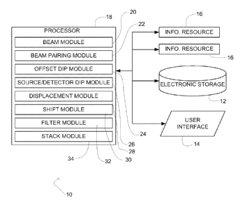
FIG. 1 illustrates a system configured to process seismic data representing
the
propagation of seismic energy through a geologic volume of interest, in
accordance
with one or more embodiments of the invention.
FIG. 2 illustrates a method of processing seismic data representing the
propagation of seismic energy through a geologic volume of interest, in
accordance
with one or more embodiments of the invention.
FIG. 3 illustrates a method of processing seismic data representing the
propagation of seismic energy through a geologic volume of interest, in
accordance
with one or more embodiments of the invention.
FIG. 4 illustrates a pair of source and detector rays through a geologic
volume
of interest, according to one or more embodiments of the invention.
FIG. 5 illustrates misalignment of actual source and detector locations with
source and detector stations on a regular, predetermined mesh, in accordance
with one
or more embodiments of the invention.
4f
CA 2778700 2018-03-05
CA 02778700 2012-04-23
WO 2011/057151
PCT/US2010/055736
DETAILED DESCRIPTION OF THE INVENTION
FIG. 1 illustrates a system 10 configured to process seismic data representing
the propagation of seismic energy through a geologic volume of interest. The
seismic
energy propagates through the geologic volume of interest from one or more
source
locations at or near the geologic volume of interest to one or more detector
locations
at or near the geologic volume of interest. In processing the seismic data,
system 10
models the seismic energy as beams (e.g., Gaussian beams). The processing
performed by system 10 (i) corrects for misalignment of the one or more source
locations and/or the one or more detector locations with a regularly spaced
mesh of
recording stations, and (ii) steers the seismic data based on the modeled
beams. In
one embodiment, system 10 comprises electronic storage 12, a user interface
14, one
or more information resources 16, one or more processors 18, and/or other
components.
In one embodiment, electronic storage 12 comprises electronic storage media
that electronically stores information. The electronic storage media of
electronic
storage 12 may include one or both of system storage that is provided
integrally (i.e.,
substantially non-removable) with system 10 and/or removable storage that is
removably connectable to system 10 via, for example, a port (e.g., a USB port,
a
firewire port, etc.) or a drive (e.g., a disk drive, etc.). Electronic storage
12 may
include one or more of optically readable storage media (e.g., optical disks,
etc.),
magnetically readable storage media (e.g., magnetic tape, magnetic hard drive,
floppy
drive, etc.), electrical charge-based storage media (e.g., EEPROM, RAM, etc.),
solid-
state storage media (e.g., flash drive, etc.), and/or other electronically
readable storage
media. Electronic storage 12 may store software algorithms, information
determined
by processor 18, information received via user interface 14, information
received
from information resources 16, and/or other information that enables system 10
to
function properly. Electronic storage 12 may be a separate component within
system
10, or electronic storage 12 may be provided integrally with one or more other
components of system 10 (e.g., processor 18).
User interface 14 is configured to provide an interface between system 10 and
a user through which the user may provide information to and receive
information
from system 10. This enables data, results, and/or instructions and any other
communicable items, collectively referred to as "information," to be
communicated
5
CA 02778700 2012-04-23
WO 2011/057151
PCT/US2010/055736
between the user and the system 10. As used herein, the term -user" may refer
to a
single individual or a group of individuals who may be working in
coordination.
Examples of interface devices suitable for inclusion in user interface 14
include a
keypad, buttons, switches, a keyboard, knobs, levers, a display screen, a
touch screen,
speakers, a microphone, an indicator light, an audible alarm, and a printer.
In one
embodiment, user interface 14 actually includes a plurality of separate
interfaces.
It is to be understood that other communication techniques, either hard-wired
or wireless, are also contemplated by the present invention as user interface
14. For
example, the present invention contemplates that user interface 14 may be
integrated
with a removable storage interface provided by electronic storage 12. In this
example, information may be loaded into system 10 from removable storage
(e.g., a
smart card, a flash drive, a removable disk, etc.) that enables the user(s) to
customize
the implementation of system 10. Other exemplary input devices and techniques
adapted for use with system 10 as user interface 14 include, but are not
limited to, an
RS-232 port, RF link, an IR link, modem (telephone, cable or other). In short,
any
technique for communicating information with system 10 is contemplated by the
present invention as user interface 14.
The information resources 16 include one or more sources of information
related to the geologic volume of interest and/or the process of generating an
image of
the geologic volume of interest. By way of non-limiting example, one of
information
resources 16 may include seismic data acquired at or near the geologic volume
of
interest, information derived therefrom, and/or information related to the
acquisition.
The seismic data may include individual traces of seismic data, or the data
recorded at
on one channel of seismic energy propagating through the geologic volume of
interest
from a source. The information derived from the seismic data may include, for
example, a velocity model, beam properties associated with beams used to model
the
propagation of seismic energy through the geologic volume of interest, Green's
functions associated with beams used to model the propagation of seismic
energy
through the geologic volume of interest, and/or other information. Information
related to the acquisition of seismic data may include, for example, data
related to the
position and/or orientation of a source of seismic energy, the positions
and/or
orientations of one or more detectors of seismic energy, the time at which
energy was
6
CA 02778700 2012-04-23
WO 2011/057151
PCT/US2010/055736
generated by the source and directed into the geologic volume of interest,
and/or other
information.
Processor 18 is configured to provide information processing capabilities in
system 10. As such, processor 18 may include one or more of a digital
processor, an
analog processor, a digital circuit designed to process information, an analog
circuit
designed to process information, a state machine, and/or other mechanisms for
electronically processing information. Although processor 18 is shown in FIG.
1 as a
single entity, this is for illustrative purposes only. In some
implementations,
processor 18 may include a plurality of processing units. These processing
units may
be physically located within the same device or computing platform, or
processor 18
may represent processing functionality of a plurality of devices operating in
coordination.
As is shown in FIG. 1, processor 18 may be configured to execute one or more
computer program modules. The one or more computer program modules may
include one or more of a beam module 20, a beam pairing module 22, an offset
dip
module 24, a source/detector dip module 26, a displacement module 28, a shift
module 30, a filter module 32, a stack module 34, and/or other modules.
Processor 18
may be configured to execute modules 20, 22, 24, 26, 28, 30, 32, and/or 34 by
software; hardware; firmware; some combination of software, hardware, and/or
firmware; and/or other mechanisms for configuring processing capabilities on
processor 18.
It should be appreciated that although modules 20, 22, 24, 26, 28, 30, 32, and
34 are illustrated in FIG. 1 as being co-located within a single processing
unit, in
implementations in which processor 18 includes multiple processing units, one
or
more of modules 20, 22, 24, 26, 28, 30, 32, and/or 34 may be located remotely
from
the other modules. The description of the functionality provided by the
different
modules 20, 22, 24, 26, 28, 30, 32, and/or 34 described below is for
illustrative
purposes, and is not intended to be limiting, as any of modules 20, 22, 24,
26, 28, 30,
32, and/or 34 may provide more or less functionality than is described. For
example,
one or more of modules 20, 22, 24, 26, 28, 30, 32, and/or 34 may be
eliminated, and
some or all of its functionality may be provided by other ones of modules 20,
22, 24,
26, 28, 30, 32, and/or 34. As another example, processor 18 may be configured
to
7
CA 2778700 2017-04-11
execute one or more additional modules that may perform some or all of the
functionality attributed below to one of modules 20, 22, 24, 26, 28, 30, 32,
and/or 34.
The beam module 20 is configured to perform ray-tracings through the
geologic volume of interest to determine central rays for beams of seismic
energy that
are propagated through the geologic volume of interest. The ray-tracings are
performed by beam module 20 based on the recording geometry of the seismic
data
and/or information derived from the acquisition of the seismic data. The
seismic data
and/or the related information (e.g., recording geometry, etc.) may be
obtained by
beam module 20 from one of information resources 16, from electronic storage
12,
from a user via user interface 14, and/or otherwise obtained. In one
embodiment.
beam module 20 uses a velocity model of the geologic volume of interest. The
velocity model may be obtained from an external source, such as one of
information
resources 16.
In one embodiment, the ray-tracings performed by beam module 20
correspond to individual midpoint-offset beaming locations. In other words,
the ray-
tracings performed by beam module 20 correspond to individual sets of source
location/detector location. As such, a given ray-tracing performed by beam
module
20 will result in rays being traced in a plurality of directions from each of
the source
and detector locations corresponding to the given ray-tracing. For a given
offset, the
midpoint and angular sampling for the rays may be determined by relations such
as
those provided as equations (26) and (27) of Hill, N. R., 2001, Prestack
Gaussian-
beam depth migration: Geophysics, vol. 66, pp. 1240-1250 ("Hill").
In addition to determining central rays from the ray-tracings described above,
beam module 20 is configured to determine other beam properties of the beams
with
central rays determined in the ray-tracings. The other beam properties may
include
one or more of travel time, beam width, amplitude, velocity, phase, raypath
direction,
and/or other beam properties at all points touched by a given beam. In one
embodiment, beam module 20 determines the beam properties for Gaussian beams.
The beam pairing module 22 is configured to identify beam pairs for a given
midpoint-offset beaming location based on midpoint dip. To identify such beam
pairs, beam pairing module 22 analyzes sets of beams for which beam properties
have
8
CA 02778700 2012-04-23
WO 2011/057151
PCT/US2010/055736
been determined by beam module 20. In particular, for a given midpoint offset
beaming location, beam pairing module 22 analyzes the beams traced from the
source
location corresponding to the given midpoint offset beaming location and the
beams
traced from the detector location corresponding to the given midpoint offset
beaming
location. In analyzing these beams, beam pairing module 22 pairs beams from
the
source location with beams from the detector location such that the sum of the
dips of
the paired beams, which is the midpoint dip of the beam pair, is constant.
Midpoint dip may be defined according to the following relationship:
(1)
wherein Pm represents midpoint dip, Pc represents beam dip at the source
location, and
Pd represents beam dip at the detector location. The source and detector dips
are
defined as:
(
2 sin Os = sinGd
5 ) P
¨ P ____ .
Vs
where Os and Od are the takeoff angles of the source ray and the detector
rays, as is
illustrated in FIG. 4, and Vs and Vd are the seismic velocities at the source
and detector
positions. Midpoint dip is the slope of an event traveltime as a function of
midpoint
when offset is held constant.
In one embodiment, in identifying beam pairs for a given midpoint-offset
beaming location, beam pairing module 22 pairs beams from the source location
with
beams from the detector location such that the identified beam pairs have a
predetermined midpoint dip. In this embodiment, beam pairing module 22 may
make
multiple passes through the beams for the given midpoint-offset beaming
location to
identify beam pairs at a plurality of different midpoint dips.
The offset dip module 24 is configured to determine offset dip for beam pairs
identified by beam pairing module 22 that makes total travel time stationary
with
respect to offset dip. Generally, offset dip can be expressed as:
(3) Ph = Pd Pc;
where Ph represents offset dip.
9
CA 02778700 2012-04-23
WO 2011/057151
PCT/US2010/055736
As will be appreciated, this determination is made for an individual beam pair
separately for different points in the geologic volume of interest that are
touch by both
beams included in the individual beam pair. For instance, for a given beam
pair at a
given point ri within the geologic volume of interest that is touched by both
beams in
the given beam pair, offset dip module 24 determines offset dip for the given
beam
pair such that the total travel time of the beam pair through the given point
ri is
stationary. The total travel time can be expressed as a function of midpoint
dip and
offset dip as follows:
(4) Tata' T d(Phi + Ph) T,(P. Ph);
wherein Tot,/ represents total travel time, Td represents travel time from the
detector
location to the point ri, and Ts represents travel time from the source
location to the
point ri. The stationary condition is
PT
(5) tot.; =0.
PPh
Note that for the case of Gaussian beams the travel times are complex numbers.
In one embodiment, for an individual midpoint dip at a given midpoint-offset
beaming location, offset dip module 24 determines offset dips for beam pairs
having
the individual midpoint dip that make total travel time stationary for the
beam pairs
through a plurality of points in the geologic volume of interest touched by
the beam
pairs. For example, by implementing the relationship set forth above in
equation (4),
offset dip module 24 may determine at individual points r within the geologic
volume
of interest one or more stationary total travel times Ttotal and offset dips
Ph at which
this stationary value occurs. This results in the determination of a plurality
of data
tuples T total(r,), P h(r,) for the individual midpoint dip at the given
midpoint-offset
beaming location.
In one embodiment, offset dip module 24 converts the data tuples Ttotai(r),
P h(r i) into a determination of offset dip Ph as a function of the real part
of the
stationary total travel time (Tr=RetTiotail), which may be expressed as
Ph(Tr). For
example, the data tuples T r(r), P h(r i) may be plotted and/or otherwise
correlated, and
a function defining the offset dip Ph as a function of travel time Tr can be
derived
based on the trends between this relationship apparent form the data tuples
Tt(ri),
CA 02778700 2012-04-23
WO 2011/057151
PCT/US2010/055736
Ph(r) as a whole. Since the determination of offset dip Ph as a function of
travel time
Tr by offset dip module 24 is for the individual midpoint dip, the determined
function
can be expressed with the individual midpoint dip as the data tuple Pm,Ph(T,),
where
Pm is the individual midpoint dip. The principal contributions to the image
occur at
these stationary points because the beams in a nearby neighborhood sum
constructively. These stationary values are therefore used to shift misaligned
traces to
nearby regularly spaced stations, as is illustrated in FIG. 4.
Returning to FIG. I, the source/detector dip module 26 is configured to
determine, for an individual midpoint dip at a given midpoint-offset beaming
location,
beam dip at the source location corresponding to the given midpoint-offset
beaming
location and beam dip at the detector location corresponding to the given
midpoint-
offset beaming location as functions of time. For example, from the data tuple
Pm,
Ph(Tr) determined for the individual midpoint dip at the given midpoint-offset
beaming location by offset dip module 24, source/detector dip module 26 may
determine the beam dip at the source location Ps and the beam dip at the
detector
location Pd as functions of time from the relationships set forth above in
equations (1)
and (3).
The displacement module 28 is configured to determine positional
displacements of source and/or detector locations during data acquisition from
regularly spaced recording stations that form a recording mesh (see FIG. 5).
To
determine positional displacement for a given source location (e.g.,
corresponding to a
given midpoint-offset beaming location) during data acquisition, displacement
module 28 compares the actual source location during the data acquisition with
a
source location on a nearby recording station of the regularly spaced
recording mesh
and determines a displacement distance therebetween. To determine positional
displacement for a given detector location, displacement module 28 compares
the
actual detector location during data acquisition with a nearby recording
station of the
regularly spaced recording mesh and determines a displacement there between.
The shift module 30 is configured to apply time shifts to traces of seismic
data
that effectively shift that actual source and/or detector location(s)
corresponding to the
traces to source and/or detector location(s) on stations of the regularly
spaced
recording mesh. The time shifts applied by shift module 30 are time varying.
For a
given trace of seismic data from a source location to a detector location that
11
CA 02778700 2012-04-23
WO 2011/057151
PCT/US2010/055736
correspond to a given midpoint-offset beaming location, the time shift applied
to the
given trace is determined by shift module 30 based on (i) beam dip at the
source
location as a function of time (e.g., as determined by source/detector dip
module 26),
(ii) beam dip at the detector location as a function of time (e.g., as
determined by
source/detector dip module 26), (iii) displacement between the actual source
location
and a source location on a station of the regularly spaced recording mesh
(e.g., as
determined by displacement module 28), and (iv) displacement between the
actual
detector location and a detector location on a station of the regularly spaced
recording
mesh (e.g., as determined by displacement module 28).
In one embodiment, shift module 30 determines the shift applied to the given
trace according to the following relationship:
(6) dT(T) = Ps(T)= dxs + Pd (T) = dX d
where ciT(T) represents the time shift as a function of time, clx., represents
the
displacement between the actual source location and the source location on a
station
of the regularly spaced recording mesh, and dxd represents the displacement
between
the actual source location and the source location on a station of the
regularly spaced
recording mesh (see FIG. 5).
In one embodiment, the regularized traces are transformed to beams by a
localized slant stacking operation such as described by Hill (2001) (see,
e.g., equation
(11) of Hill (2001)). This transformation may include a filter that localizes
the traces
in space about the beaming midpoint Xin.
1 co 0;2¨ ,n)
(7) f (co) = exp X
2w0 w2
0 /
where X,, represents the midpoint of the trace being filtered after the time
shift is
applied by shift module 30, co represents frequency, oo represents a filtering
frequency, and rõ, represents a point in the geologic volume of interest
touched by the
trace being filtered. This filter may be applied, for example by a filter
module 32.
The stack module 34 is configured to stack traces. The traces near beaming
midpoint location Xn, and offset h are stacked after being shifted and/or
filtered as
described above. In one embodiment, stack module 34 slant stacks traces by
applying
a time delay to the traces before summing them. The time delay may be
determined,
for example, as:
12
CA 02778700 2012-04-23
WO 2011/057151
PCT/US2010/055736
(8) AT = P. = (r. ¨ X .)
where AT represents the time delay (see, e.g., Hill (2001), equation (11)).
This time
delay and local stacking operation separates the recorded data into beam
components.
After having been stacked at stack module 34, the resulting beam components
of the seismic data may then be implemented to image the geologic volume of
interest. The imaging may be performed by processor 18, and/or the stacked
traces
may be stored (e.g., to electronic storage 12) for processing at another time
and/or on
another system.
FIG. 2 illustrates a method 36 of processing seismic data representing the
propagation of seismic energy through a geologic volume of interest. The
operations
of method 36 presented below are intended to be illustrative. In some
embodiments,
method 36 may be accomplished with one or more additional operations not
described, and/or without one or more of the operations discussed.
Additionally, the
order in which the operations of method 36 arc illustrated in FIG. 2 and
described
below is not intended to be limiting.
In some embodiments, method 36 may be implemented in one or more
processing devices (e.g., a digital processor, an analog processor, a digital
circuit
designed to process information, an analog circuit designed to process
information, a
state machine, and/or other mechanisms for electronically processing
information).
The one or more processing devices may include one or more devices executing
some
or all of the operations of method 36 in response to instructions stored
electronically
on an electronic storage medium. The one or more processing devices may
include
one or more devices configured through hardware, firmware, and/or software to
be
specifically designed for execution of one or more of the operations of method
36.
At an operation 38, the spatial and angular sampling for beams of seismic
energy through the geologic volume of interest is determined. The spatial and
angular
sampling for the beams of seismic energy may be determined from the frequency
bandwidth seismic data acquired at or near the geologic volume of interest
and/or the
beam sampling relations such as the ones that appear at equations (26) and
(27) of
Hill (2001).
13
CA 02778700 2012-04-23
WO 2011/057151
PCT/US2010/055736
More particularly, equation (26) of Hill (2001) specifies that a constant a
that
governs spatial sampling (e.g., to create a lattice of Dirac delta functions
spaced at
27c/a) should be determined according to the following relationship:
co,
(9)
Ai oh
where wi represents the initial width of a beam, (Di represents a reference
frequency at
the lower end of the seismic data bandwidth, and Oh represents a reference
frequency
at the higher end of the seismic data bandwidth.
Equation (27) of Hill (2001) specifies an angular sampling according to the
following relationship:
(10) AP., = = 1
1421 11 COI COh
where AP, and APy represent the angular spacing of sampling in the x and y
directions, respectively.
At an operation 40 a midpoint-offset beaming location at or near the geologic
volume of interest is identified. The midpoint-offset beaming location
corresponds to
a specific midpoint and offset. A source location corresponding to the
midpoint-
offset beaming location is expressed as:
(11) Xs =X '
¨V=
/ 2
where X, represents the source location, X), represents the midpoint location
of the
midpoint-offset beaming location, and h represents the offset. Similarly, a
detector
location Xd corresponding to the midpoint-offset beaming location is expressed
as:
(12) Xd = X +y
in 2 =
Fig. 4 illustrates these relations along a single coordinate axis x; the
quantities
, X, X and h are in general two-dimensional vectors in a horizontal coordinate
plane.
At an operation 42, a ray-tracing is performed for the identified midpoint-
offset beaming location. In the ray-tracing, ray paths of rays traveling from
the source
14
CA 02778700 2012-04-23
WO 2011/057151
PCT/US2010/055736
location through the geologic volume of interest are determined, and ray paths
of rays
traveling from the detector location through the geologic volume of interest
are
determined. In one embodiment, operation 42 is performed by a beam module 20
that
is the same as or similar to beam module 20 (shown in FIG. 1 and described
above).
At an operation 44, beam properties for beams of seismic energy propagating
along the ray paths traced at operation 42 are determined. The beam properties
determined at operation 44 may include one or more of travel time, beam width,
amplitude, velocity, phase, raypath direction, and/or other properties at all
points
touched by the beam. In one embodiment, operation 44 is performed by a beam
module 20 that is the same as or similar to beam module 20 (shown in FIG. 1
and
described above).
At an operation 46, a midpoint dip is identified. At an operation 48, beam
pairs at the midpoint-offset beaming location having the midpoint dip from
operation
46 are identified. Each beam pair may include a beam traveling from the source
location and a beam traveling from the detector location such that beam dip at
the
source location and beam dip at the detector location satisfy the midpoint dip
from
operation 46 (e.g., Pm=Ps+Pd). In one embodiment, operation 48 is performed by
a
beam pairing module that is the same as or similar to beam pairing module 22
(shown
in FIG. 1 and described above).
At an operation 50, offset dips that make total travel times of the beam pairs
identified at operation 48 stationary at points within the geologic volume of
interest
are determined. In one embodiment, operation 50 is performed by an offset dip
module that is the same as or similar to offset dip module 24 (shown in FIG. 1
and
described above).
At an operation 52, for the beam pairs identified at operation 48, beam dip at
the source location and beam dip at the detector location are determined as a
function
of time. The determination of beam dip at the source location and beam dip at
the
detector location is based on the midpoint dips and the offset dips determined
for the
beam pairs at operation 50. In one embodiment, operation 52 is performed by a
source/detector dip module that is the same as or similar to source/detector
dip
module 26 (shown in FIG. 1 and described above).
CA 02778700 2012-04-23
WO 2011/057151
PCT/US2010/055736
At an operation 54, a trace of seismic data at or near midpoint-offset beaming
location is obtained. At an operation 56, a time shift is applied to the trace
of seismic
data that effectively shifts the actual source location and the actual
detector location
of the trace of seismic data to the source location and the detector location
at stations
of a regularly spaced recording mesh. The time shift is time varying. The time
shift
is based on beam dip at a source location corresponding to the given midpoint-
offset
beaming location and beam dip at a detector location corresponding to the
given
midpoint-offset beaming location as a function of time (e.g., as determined at
operation 52 and as illustrated in FIG. 4), and is also based on a positional
displacements between the actual source and detector locations of the seismic
data
trace and the source and detector locations at stations on the regularly
spaced
recording mesh, and/or based on other parameters. In one embodiment, operation
56
is performed by a shift module that is the same as or similar to shift module
30
(shown in FIG. 1 and described above).
At an operation 58, the shifted trace is filtered. In one embodiment,
operation
58 is performed by a filter module that is the same as or similar to filter
module 32
(shown in FIG. 1 and described above).
At an operation 60, the shifted trace may be stacked. The stacking may
include applying a time delay to the shifted trace, and summing the shifted
trace with
other previously processed traces. In one embodiment, operation 60 is
performed by
a stack module that is the same as or similar to stack module 34.
Method 36 includes a loop 62 that loops back over operations 54, 56, 58,
and/or 60 for all of the available traces of seismic data that are at or near
the
midpoint-offset beaming location. Upon completing loop 60, method 36 includes
a
loop 64 that loops back over operations 46, 48, 50, 52, and loop 60 for a
plurality of
midpoint dips at the midpoint-offset beaming location identified at operation
40.
Upon completing loop 64, method 36 includes a loop 66 that loops back over
operations 40, 42, 44, and loop 62 for a plurality of midpoint-offset beaming
locations. In one embodiment, loop 66 actually includes two separate loops.
For
example one of the loops may loop over a plurality of midpoint locations at a
given
offset, while the other loop loops over a plurality offsets.
16
CA 02778700 2012-04-23
WO 2011/057151
PCT/US2010/055736
FIG. 3 illustrates a method 68 of processing seismic data obtained at or near
a
geologic volume of interest. In particular, method 68 involves determining,
for a
given midpoint-offset beaming location and a given midpoint dip, beam dip at a
source location corresponding to the given midpoint-offset beaming location
and
beam dip at a detector location corresponding to the given midpoint-offset
beaming
location as a function of time. In one embodiment, method 68 may be
implemented
as a component of an over-arching method. For example, method 68 may be
implemented as operations 50 and/or 52 within method 36 shown in FIG. 2 and
described above. This is not intended to be limiting, and method 68 may be
implemented within a variety of other contexts.
The operations of method 68 presented below are intended to be illustrative.
In some embodiments, method 68 may be accomplished with one or more additional
operations not described, and/or without one or more of the operations
discussed.
Additionally, the order in which the operations of method 68 are illustrated
in FIG. 3
and described below is not intended to be limiting.
In some embodiments, method 68 may be implemented in one or more
processing devices (e.g., a digital processor, an analog processor, a digital
circuit
designed to process information, an analog circuit designed to process
information, a
state machine, and/or other mechanisms for electronically processing
information).
The one or more processing devices may include one or more devices executing
some
or all of the operations of method 68 in response to instructions stored
electronically
on an electronic storage medium. The one or more processing devices may
include
one or more devices configured through hardware, firmware, and/or software to
be
specifically designed for execution of one or more of the operations of method
68.
At an operation 70, beam pairs at the midpoint-offset beaming location having
the given midpoint dip are obtained. In one embodiment, operation 70 involves
obtaining the output of an operation that is the same as or similar to
operation 48
(shown in FIG. 2 and described above).
At an operation 72, a point within the geologic volume of interest is
identified
as being touched by both beams included in one of the beam pairs obtained at
operation 70. In one embodiment, operation 72 is performed by an offset dip
module
17
CA 02778700 2012-04-23
WO 2011/057151
PCT/US2010/055736
that is the same as or similar to offset dip module 24 (shown in FIG. 1 and
described
above).
At an operation 74, an offset dip for the beam pair that touches the point
within geologic volume of interest identified at operation 72 is determined.
Specifically, the offset determined at operation 74 makes total travel time
for the
beam pair at the point within the geologic volume of interest stationary. In
one
embodiment, operation 74 is performed by an offset dip module that is the same
as or
similar to offset dip module 24 (shown in FIG. 1 and described above).
At an operation 76, the offset dip determined at operation 74 is stored as a
data
tuple, or set, with the travel time for the beam pair through the point in the
geologic
volume of interest at the determined offset dip. In one embodiment, operation
76 is
performed by an offset dip module that is the same as or similar to offset dip
module
24 (shown in FIG. 1 and described above).
Method 68 includes a loop 78 that loops back over operations 72, 74, and 76
for a plurality of points that are touched by one or more of the beam pairs
obtained at
operation 70. Upon completing loop 78, method 68 proceeds to an operation 80.
At the operation 80, offset dip for the beam pairs obtained at operation 70 is
determined as a function of time. This determination is based on the data
tuples
stored at operation 76. In one embodiment, operation 80 is performed by an
offset dip
module that is the same as or similar to offset dip module 24 (shown in FIG. 1
and
described above).
At an operation 82, for the given midpoint-offset beaming location and the
given midpoint dip, beam dip at the source location and beam dip at the
detector
location are determined as a function of time. Specifically, from the
relationship
describing offset dip as a function of time that is determined at operation
80, and from
the given midpoint dip, beam dip at the source location and beam dip at the
detector
location are determined. In one embodiment, operation 82 is performed by a
source/detector dip module that is the same as or similar to source/detector
dip
module 26 (shown in FIG. 1 and described above).
Although the invention has been described in detail for the purpose of
illustration based on what is currently considered to be the most practical
and
preferred embodiments, it is to be understood that such detail is solely for
that
18
CA 02778700 2012-04-23
WO 2011/057151
PCT/US2010/055736
purpose and that the invention is not limited to the disclosed embodiments,
but, on the
contrary, is intended to cover modifications and equivalent arrangements that
are
within the spirit and scope of the appended claims. For example, it is to be
understood that the present invention contemplates that, to the extent
possible, one or
more features of any embodiment can be combined with one or more features of
any
other embodiment.
19