Note: Descriptions are shown in the official language in which they were submitted.
CA 02888335 2015-04-14
WO 2014/062109
PCT/SE2013/000160
Method and system for monitoring road conditions
BACKGROUND
There is a need among private and public owners of roads, railroads and
bicycle roads, as well as companies supplying maintenance services to these
owners, to continuously maintain an objective overview of the condition of
their respective road networks. They also need to objectively monitor both
the immediate effects of road maintenance activities and the effects over time
of different alternative approaches. This has so far been difficult, due both
to
1 0 the prohibitive costs of frequently using specialized road condition
measuring vehicles and to the lack of a modern and flexible standard for
road quality presentation and comparisons. The currently used road quality
standard, IRI- International Roughness Index, faces common and important
complaints, e.g. that it is speed dependent and mostly measured in fixed
lengths which makes it hard to scale up, to present on maps and to refer to
road links in modern road geometry databases. For navigation and Road
Condition Routing Services (RCRS), it would be of very high interest to be
able to provide private and professional road users with a Comfort Level at
proposed routes.
2 0 In developing countries, road condition measuring vehicles are often
not
available at all, leaving subjective ocular road condition assessments as the
only alternative, such having been proven to be both inconsistent and prone
to undue influences from people who may gain from certain allocations of
road maintenance resources. In developing countries it would also encourage
2 5 development cooperation investors in infrastructure projects if they
could
remotely monitor the road quality development.
SUMMARY
An object of the present invention is to provide a method and system for
3 0 collecting and/or monitoring road conditions that is easy to accomplish
with
relatively simple means and which at the same time provides for scalability
and general use.
SUBSTITUTE SHEET (RULE 26)
CA 02888335 2015-04-14
WO 2014/062109 2
PCT/SE2013/000160
A method for monitoring road conditions comprising in one embodiment the
steps of:
a) measuring a vehicle movement quantity associated with a present
road condition at a plurality of occasions, also referred to as sampling;
b) recording a respective position at which the measuring (sampling)
was performed;
c) in certain embodiments assigning a measurement time to the
position and assigned RCC
d) assigning a road condition class (RCC), out of a number of predefined
RCCs, to the position;
e) in certain embodiments communicating the positions with assigned
RCCs and assigned measurement times to a road condition database
(RCD)
I) storing the positions with assigned RCCs and assigned
measurement
times in a road condition database (RCD); and
g) determining a consolidated RCC (CRCC), out of the predefined RCCs,
for a target road section or road area
h) presenting the CRCC for the target road section or road area
Steps a-d, and in certain embodiments step e or step f, are performed by a
2 0 measuring unit mounted at a vehicle in motion.
In step d, the (sampled) vehicle movement quantities are compared with type
calibration data to form the road condition class (RCC) assigned to the
position. Type calibration data are pre-defined relations between vehicle
movement quantities and road condition classes for the specific type of
2 5 measuring unit and the specific type of vehicle being used.
Steps f-h may in different embodiments be performed by the measuring unit,
by a computer system, by a computer program or by a computer program
product.
In step g, the RCD is utilized to determine a consolidated road condition
30 class (CRCC) for a target road section or a target area. This is done by
forming a distribution of stored road condition classes within the road
section or area and selecting a consolidated road condition class to represent
the distribution of road condition classes. In one implementation, this
SUBSTFuTE RuLE 26
CA 02888335 2015-04-14
WO 2014/062109 3
PCT/SE2013/000160
selection is based on calculating a rounded weighted average of the
distribution.
In step h, the position and measured road condition class, or consolidated
road condition class for the target road section or area, may then be
presented, for example graphically or in reports, or communicated to other
databases or other computer systems.
One aspect of the present innovation is a system for monitoring road
conditions comprising: at least one measuring unit, being mountable at a
respective vehicle; and a road condition database server.
The measuring unit will at least have: a vehicle movement sensor: operable
to measure a vehicle movement quantity associated with a present road
condition; a positioning unit, operable to record a position at which the
measurement is performed; a communication unit, operable to communicate
data to said road condition database server.
1 5 The road condition database server will have at least a receiver for
receiving
data from the measuring unit(s), and a memory.
The system will be operable to assign a road condition class, out of a limited
number of road condition classes, to a position, as earlier described based
on measured vehicle movement quantities being compared with type
2 0 calibration data; possibly to store a measurement time; store positions
and
assigned road condition classes and possibly a measurement time in a road
condition database in the memory; and the road condition database server
being further operable to determine and present a consolidated road
condition class from a road condition distribution, as earlier described.
2 5 Another aspect of the present innovation is a computer program, which
causes a processing circuitry to: obtain a plurality of positions and thereto
assigned road condition classes; store positions and assigned road condition
classes in a road condition database; determine a consolidated road
condition class, for a target road section or a target area, by forming a
3 0 distribution of stored road condition classes in the ways earlier
described;
and present the consolidated road condition class.
Yet another aspect of the present innovation is a computer program product
on which a computer program is stored that when executed measure
SUBSTITUTE SHEET (RULE 26)
CA 02888335 2015-04-14
WO 2014/062109 4
PCT/SE2013/000160
movements, records positions and assigns road condition classes as described
earlier, and either communicates positions and road condition classes to a
road condition database or stores these data in a road condition database
where consolidated road condition data are obtained in ways earlier
described, and different road condition data are presented for a target road
section or a target area.
DETAILED DESCRIPTION
The present disclosure presents a method to monitor road quality by
assigning roads with calibrated, objective and comparable Road Condition
Classes (RCCs). This is done according to a fully scalable new standard for
road quality, here denominated 'The Roadroid Index' (TRI). In one
embodiment, schematically illustrated in Fig. 1, recorded positions obtained
by a satellite-based navigation system are assigned RCCs and measurement
times by one or more measuring units 10 mounted at normal vehicles 20
travelling on roads, railroads, bicycle roads, etc. are communicated to a
Road Condition Database server 30.
The RCCs are assigned out of a number of predefined road condition classes,
in one embodiment envisaged to be represented by the four integer values 1-
2 0 4. For presentation purposes, the different RCCs in the range may also
be
assigned color codes, e.g.:
1=green=Good, 2=yellow= Satisfactory,
3=red=Unsatisfactory and 4=black=Poor. In alternative embodiments other
number of RCCs is used. The predefined number of RCCs should preferably
be selected considering data storage capacity, available transmission
2 5 resources, accuracy in RCC assignment and presentation lucidity.
TRI on an aggregated level consists in one embodiment of both a RCC
distribution for the level and a consolidated RCC (CRCC) for that level
assigned as a single representation of the RCC distribution. An aggregated
level can e.g. be road links in a road geometry, certain road sections, a part
30 or all of a road network, a target area etc. The RCC distribution is in
a
particular embodiment represented by the percentage of road condition
values, among all points considered on the level, that adheres to each of the
respective RCC integer numbers in the range, e.g.: % 'green' points (1s),
SUBSTITUTt SF__,.1EiLf111 2'))
CA 02888335 2015-04-14
WO 2014/062109 5
PCT/SE2013/000160
%'yellow' points(2s), %'red' points(3s) and %'black' points(4s) if four RCCs
are used. In other embodiments, other types of RCC distributions measures
can be used. The CRCC for an aggregated level is in one embodiment
calculated as a weighted average of the RC distribution for the level (a real
number that may be rounded to an integer for presentation purposes). In
other embodiments, other types of averages or typical values can be used for
expressing the overall RCC. An illustration of how CRCCs could be
calculated in one embodiment with one choice of weights is presented below:
weights 1 1 1 3
No of RCCs GreenYellowRed Black Total
Road Link 1.1 10 10 5 5 30
Road Link 1.2 8 10 10 32 60
Road Link 1.3 60 10 20 30 120
TOTAL ROAD 3 78 30 35 67 210
Distribution
CRCC GreenYellowRed Black Ave. W. Av. CRCC
Road Link 1.1 33% 33% 17% 17% 2,2 2,6 Yellow
Road Link 1.2 13% 17% 17% 53% 3,1 3,6 Black
Road Link 1.3 50% 8% 17% 25% 2,2 2,8 Red
TOTAL ROAD3 37% 14% 17% 32% 2,4 3,0 Red
A measuring unit may in different embodiments be a smartphone or may
consist of other equipment mounted to the vehicle for the purpose. In one
embodiment, the measuring unit is a smartphone mounted in a fixed
bracket to the vehicle and running a special program for the purpose. A
measuring unit will need to include at least one sensor by which the road
condition can be computed (typically an inertial sensor for vibrational
sampling), and at least one GPS sensor for geographical positioning.
Preferably, the measuring unit also comprises at least one time stamp device
to decide the point in time when a measurement is made and at least one
digital memory device.
SUBSTITUTE SHEET (RU1,7: 2C1
CA 02888335 2015-04-14
WO 2014/062109 6
PCT/SE2013/000160
A measuring unit will also need to include at least one digital processing
device and at least one device to communicate data, preferably as being
stored in the digital memory device, to an external computer server by direct
or indirect means. The aforementioned parts of the measuring unit may
preferably be combined into multi-function device(s) rather than separate
devices. One non-exclusive example is the earlier mentioned smartphone
equipped with the necessary functionalities. The measuring unit may in
alternative embodiments also be dedicated equipment for this purpose. The
measuring unit may in further alternative embodiments also carry further
sensors, as well as recorders of complementary data/ information such as
voice recordings, pictures and video. One embodiment of a measuring unit
10 is schematically illustrated in Fig. 2. This embodiment includes a
processing device 12, a satellite navigation device 14, a movement sensor
device 15, a timing device 16, a digital memory device 17, a communication
1 5 device 13 and an antenna device 11 for wireless communication.
Since the measurement units can be based on a relatively simple and
inexpensive platform, a large number of units can be provided also by a
limited budget. By in some embodiments attaching the measurement units
to vehicles that are traveling a lot on various roads, e.g. post delivery
vehicles, community service vehicles etc., large number of measurement
points can be obtained. Such a crowd sourcing may provide a data base with
extremely good accuracy and statistics both in position and time. In other
embodiments, measuring units may be used by professional road staff for
high precision purposes or for concurrent collection of complementary
2 5 information by advanced sensors or other equipment.
Preferably, each combination of measuring unit type and vehicle type to be
used will be calibrated to recognize the different predefined standard levels
(RCCs) of road quality. The calibration is in one embodiment performed
empirically in realistic situations, e.g. by test runs a certain number of
times
3 0 at a certain number of different speeds on a test track with a certain
number
of standardized obstructions. In alternative embodiments, calibration may be
performed in a laboratory setting where all calibration vectors may be
simulated. The measurement characteristics can in such a way be
SUBSTITUTE SHEET CUE 75i,7;)
CA 02888335 2015-04-14
WO 2014/062109 7
PCT/SE2013/000160
associated to the different RCCs. The division of measuring unit types and
vehicle types is preferably made according to the obtained accuracy and
repeatability in the calibration procedure.
For professional measuring of road condition, the use of measuring units
that have been calibrated for the different vehicle types in a controlled
environment has proven to give high repeatability across individual
units/vehicles. To achieve this high repeatability, the calibration may result
in specifications for a particular vehicle type and as an example, there are
requirements put on the tire air pressure for certain vehicles. The
alternative
to calibrate each and every unit/vehicle would generate unnecessary costs
and hassle, and probably in actual practice a lowering of calibration
standards.
During operation, the measuring unit collects in one embodiment sample
vibrational data from inertial sensor(s), e.g an accelerometer or similar
equipment, while the vehicle that carries it moves on the road, railroad or
bicycle track. Preferably, this is performed at frequencies of at least 100
samples per second. Also preferably, it is performed at a predefined
minimum speed. The measuring unit analyses the data sampled during an
assigned time period, typically 1 second, and defines the RCC for the
geographical position by assigning a predefined RCC based on the analysis.
The analysis method, which has been developed after experiences from years
of research, takes into consideration type of vehicle and type of measuring
unit/sensor. Different measuring units may have different sensors, e.g
accelerometer sensors, that give different signals, different processing
units,
etc. Hence it is important that the different sensors, different software
versions of processing units, etc. are tested and verified. Mounting in the
vehicle is also important, and the measuring units should be mounted
according to specific instructions in order to fulfil the requirements for
fitting
into a specific measuring unit/vehicle type calibration.
3 0 The RCC is preferably stored in the digital memory device together with
a
GPS coordinate. Preferably the stored information also comprises a time
stamp, a speed value (supplied by the GPS sensor directly or calculated from
GPS sensor data), and any other data of interest produced by the unit (RMS,
SUBSTITUTE SHEET (RULE `,16,
CA 02888335 2015-04-14
WO 2014/062109 8
PCT/SE2013/000160
Peak, etc.). The measuring unit may concurrently also collect recordings or
other interesting information and store these in the digital memory with GPS
coordinates and time stamps.
In one embodiment, schematically illustrated in Fig. 3, at certain times the
collected RCCs, associated GPS coordinates and corresponding additional
data, as well as any relevant and separately recorded information, are
transferred from the measuring unit to a central computer server 32. From
the computer server, this information is entered into a Road Condition
Database (RCD) 33 which may also collect auxiliary road condition
information from other sources 36. In one embodiment, the transferring of
data may be performed continuously as soon as there are available data to
send. In alternative embodiments, the data is transferred either at
predetermined occasions or when a certain amount of data has been
collected. In a presently preferred embodiment, the transfer is made by a
1 5 wireless communication technique 31. However, in particular
embodiments,
transferring of data may also be performed by wired communication paths.
By using RCCs from calibrated measuring units 10, stored in the RCD 33,
besides the simple retrieving of data associated with each set of single
measuring point, also objective TRI information can be produced for any
2 0 aggregate levels (single road links in any road geometries, specific
stretches
of roads consisting of multiple road links, whole road networks, for entire
cities and even for entire country networks, etc.). The aggregate levels may
also be divided in time or according to any other additional data. This
scalability and flexibility is achieved by the configuration of the RCD, where
25 individual measuring points are available.
TRI information may be presented in graphical format and in different kinds
of reports 35, and/or stored in the RCD itself for fast access to more limited
amounts of data. Comprehensive collection over time of TRI values in the
RCD, makes it possible to present and compare objectively prepared and
3 0 standardized TRI information in a number of different ways. Overview
graphs
and reports can be presented, and zooming in on problem areas can be done
down to single road links or even to the RCC of single GPS coordinates. The
distribution of RCCs can be studied on any aggregate level with the use of
SUBSTITUTE SHEET (RULE 26)
CA 02888335 2015-04-14
WO 2014/062109 9
PCT/SE2013/000160
TRI's distribution component. Analysis can be made of a current road
network for identification of prioritized activity areas, and evaluation of
work
performed can be done. As the TRI is correlated to IRI it is possible to
import
data to asset management systems as HDM (Highway Development and
Management). Road deterioration over time can be monitored, as well as the
effect of maintenance work over time. The interdependence between road
deterioration and different environmental factors (frost, ground composition,
etc.), maintenance materials used, maintenance methods used, etc. can be
monitored and analyzed. Based on data and experiences from similar
1 0 previous conditions, warnings can be issued for expected road problems
(e.g.
heat buckles). Communication between contractor and customer/ road
owner can be improved by the use of TRI information in different kinds of
exchanges.
The above type of analysis is performed in a data analyzer (see Fig 3). The
1 5 data analyzer may in one embodiment be comprised in the central
computer
server together with the RCD 34. In other embodiments, the data analyzer
can be provided by an external processor, connected to the RCD for retrieval
of data 38. The data analyzer may in different embodiments be constituted
as a distributed unit, with processing power from different sources.
2 0 Road Condition comparisons can also be made between different road
networks, with possibility to see both overall and distributed TRI ratings to
analyze the composition of quality within the road networks.
The information richness will increase if TRI data in the RCD is combined
with time- and GPS -stamped video/voice recordings, pictures, public
25 complaints, etc. Complementary information in the RCD, collected by the
measuring units or by other means, can easily be linked to the TRI
information. This can e.g. include recorded comments or video on a certain
stretch of road, pictures showing a certain problem, reported complaints
from the public, etc. Such information will add considerably to the richness
30 of information available from the RCD.
Comprehensive collection over time of RCCs and CRCCs into one or more
RCD(s) will allow full overview of a road network, zooming in on problem
areas, monitoring of road deterioration over time and monitoring of the effect
-----WBSTITUTE SHEET RULE
CA 02888335 2015-04-14
WO 2014/062109 10
PCT/SE2013/000160
of maintenance work. It will also allow better analysis of the interdependence
of road deterioration with different environmental factors (frost, ground
composition, etc.), maintenance materials used, maintenance methods used,
etc. The information is also of high interest for navigation and Road
Condition Routing Services (RCRS).
For navigation and routing purposes, the RC values create a whole new
service. It is of great importance for a road user's choice to take the Road
Condition into account. It's a comfort issue but it is also a road safety
issue,
especially for motorcyclists or driving on bumpy roads in combination with
ice/ black ice.
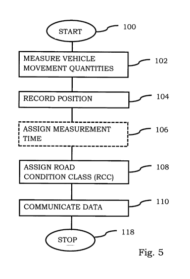
One preferred embodiment of the method comprises the steps (see Fig 4) of:
- measuring, by a measuring unit mounted at a vehicle, a vehicle
movement quantity associated with a present road condition, at a
plurality of occasions, also referred to as sampling 102;
1 5 - recording, by the measuring unit, a respective position also
referred to
as a sampling position at which the measuring was performed for the
plurality of occasions 104;
- in some embodiments assigning a measurement time 106;
- assigning a road condition class (RCC), out of a number of RCCs, to
2 0 each of those (sampling) positions, by comparing the measured
vehicle
movement quantities of the plurality of occasions with type calibration
data 108;
- in some embodiments communicating positions with corresponding
assigned RCCs and possibly measurement times to a road condition
25 database server 110;
- storing the positions and corresponding RCCs in a road condition
database (RCD) 112;
- determining a consolidated RCC (CRCC)for a target road section or a
target area, by forming a distribution of stored RCCs for positions
3 0 within the target road section or area and selecting the CRCC to be
representative for that distribution of RCCs 114; and
- presenting the CRCC for the target road section or target area 116.
SUBSTITUTE SHEET (RULE
CA 02888335 2015-04-14
WO 2014/062109 11
PCT/SE2013/000160
With reference to Fig 4, steps 102, 104, 108, and in certain embodiments
steps 106, 110, 112, 114, 116 are performed by a measuring unit mounted
at a vehicle in motion.
In step 108, the (sampled) vehicle movement quantities are compared with
type calibration data to form the road condition class (RCC) assigned to the
position. Type calibration data are pre-defined relations between vehicle
movement quantities and road condition classes for the specific type of
measuring unit and the specific type of vehicle being used.
Steps 110, 112,114 may in different embodiments be performed by the
measuring unit, by a computer system, by a computer program or by a
computer program product.
In step 114, the RCD is utilized to determine a consolidated road condition
class (CRCC) for a target road section or a target area. This is done by
forming a distribution of stored road condition classes within the road
section or area and selecting a consolidated road condition class to represent
the distribution of road condition classes. In one implementation, this
selection is based on calculating a rounded weighted average of the
distribution.
In step 116, the position and measured road condition class, or consolidated
road condition class for the target road section or area, may then be
presented, for example graphically or in reports and in certain embodiments
combined with other information collected by the measuring unit or from
external sources, or be communicated to other databases or other computer
systems.
In one embodiment of the method, the position (recorded at step 104) and
RCC (assigned at step 108) are stored in a memory in the measuring unit
and the communication performed collectively for a plurality of positions and
associated road condition classes.
In one embodiment of the method, the movement quantity (measured in step
102) is a quantity quantifying vibrations.
In one embodiment of the method, the step of recording a respective position
104 comprises positioning by use of a satellite-based navigation system.
SUBSTITUTE SHEET (RUL. 23,
CA 02888335 2015-04-14
WO 2014/062109 12
PCT/SE2013/000160
In one embodiment of the method, a measurement time is assigned to each
position and assigned road condition class 106, and this time is also stored
in the memory, RCD and any other devices, as well as further processed and
utilized in the further analysis and presentation.
In one embodiment of the method, the consolidated road condition class is
determined 114 as a rounded off weighted average of the distribution of
stored road condition classes.
One embodiment of the method includes the further step of providing a
representation of the distribution of stored RCCs together with the
1 0 presentation of the CRCCs.
One embodiment of the method includes the further step of determining a
CRCC being repeated for different target road sections or target areas and/or
optionally different target time periods, wherein the step of presenting and
of
providing are performed collectively for the different target road sections or
target areas and/or optionally different target time periods.
A system for monitoring road conditions comprises: at least one measuring
unit, being mountable at a respective vehicle; and a road condition database
server.
The measuring unit will at least have: a vehicle movement sensor: operable
2 0 to measure a vehicle movement quantity associated with a present road
condition; a positioning unit, operable to record a position at which the
measurement is performed; a communication unit, operable to communicate
data to said road condition database server.
The road condition database server will have at least a receiver for receiving
2 5 data from the measuring unit(s), and a memory.
The system will be operable to assign a RCC, out of a limited number of
RCCs, to a position, as earlier described based on measured vehicle
movement quantities being compared with type calibration data; possibly to
store a measurement time; store positions and assigned RCCs and possibly
30 measurement times in a RCD in the memory; and the RCD server being
further operable to determine and present a CRCC from a road condition
distribution, as earlier described.
SUBSTITUTE SHEET (RULE 26)
CA 02888335 2015-04-14
WO 2014/062109 13
PCT/SE2013/000160
Another aspect is a computer program, which causes a processing circuitry to:
obtain a plurality of positions and thereto assigned RCCs; store positions
and assigned RCCs in a RCD; determine a CRCC, for a target road section or
a target area, by forming a distribution of stored RCCs in the ways earlier
described; and present the CRCC.
Yet another aspect is a computer program product on which a computer
program is stored that when executed measure movements, records positions
and assigns RCCs as described earlier, and either communicates positions
and RCCs to a RCD or stores these data in a RCD where CRCC data are
obtained in ways earlier described, and different road condition data are
presented for a target road section or a target area.
SUBSTITUTE SHEET (RU1.: