Note: Descriptions are shown in the official language in which they were submitted.
PLOT PLACEMENT SYSTEMS AND METHODS
FIELD OF THE INVENTION
[0001] The present application provides a systems and methods for plot
placement, particularly for
an agricultural field.
BACKGROUND
[0002] In recent years, farmers and agronomists have increasingly recognized
the importance of
population (i.e., the number of seeds planted per acre) in maximizing yield
and profit in the
cultivation of corn and other crops. There is similar interest in maximizing
the economic benefit of
other crop inputs such as nitrogen. Thus, there is a need in the art for
systems and methods for
varying crop input application rates.
SUMMARY
[0003] The present disclosure provides for a method for generating a plot in a
field during a crop
input application operation using a variable application implement. The method
includes displaying
a geo-referenced map of the field, prompting a user to select a marker
location on the map that
corresponds to at least one geo-referenccd location in the field. The method
also includes initiating
the crop input application operation using the variable application implement
and applying a crop
input on a first portion of the field at varying application rates according
to a prescription map. The
prescription map associates each of a plurality of regions in the field with
one of a plurality of
application rates. The method also includes implementing a plot in the field,
the plot defining a plot
region within the field, the plot region being selected during the crop input
application operation
based on said marker location.
DESCRIPTION OF THE DRAWINGS
[0004] FIG. 1 is a top view of an embodiment of a row crop planter.
[0005] FIG. 2 schematically illustrates an embodiment of a system for
controlling a planter and
gathering planting data.
1
CA 2894568 2019-03-14
[0006] FIG. 3 illustrated an embodiment of a prescription map.
[0007] FIG. 4 illustrated an embodiment of a plot marker placement screen.
[0008] FIG. 5 illustrates the planter of FIG. 1 planting a field according to
the prescription map of
FIG. 3.
[0009] FIG. 6 illustrates the planter of FIG. 1 implementing a plot based on a
plot marker placed as
illustrated in FIG. 4.
[0010] FIG. 7 illustrates an embodiment of a process for implementing a plot.
[0011] FIG. 8 illustrates an embodiment of a process for determining whether a
new pass has begun.
[0012] FIG. 9 illustrates an embodiment of a process for determining whether a
pass has been
completed.
[0013] FIG. 10 illustrates an embodiment of an as-planted prescription screen.
[0014] FIG. 11 illustrates an embodiment of a plot marker placement screen
displaying a headland
boundary.
[0015] FIG. 12 illustrates another embodiment of a process for implementing a
plot.
[0016] FIG. 13 illustrates still another embodiment of a process for
implementing a plot.
DESCRIPTION
[0017] Referring now to the drawings, wherein like reference numerals
designate identical or
corresponding parts throughout the several views, FIG. 1 illustrates a top
view of a tractor 5
pulling a planter 10 used to plant row crops. The planter 10 includes a frame
12, in which a
toolbar 14 extends transversely as a mounting structure for row units 16, each
of which is
configured to plant seeds in a row as is known in the art. Each row unit 16 is
preferably
configured to plant at variable population rates (i.e., number of seeds per
acre).
Application control and monitoring system
[0018] The planter 10 preferably includes one or more drives 427 (FIG. 2),
such as hydraulic or
electric drives as are known in the art, for varying the population rate
planted by each row unit 16
or a group of row units. The planter 10 further preferably includes one or
more clutches 425
(FIG. 2) for engaging and disengaging the drives to stop or resume planting at
each row unit 16
or group of row units. The planter 10 further preferably includes one or more
seed sensors 420
2
CA 2894568 2019-03-14
(FIG. 2) for detecting the time of seed deposition as well as the population
rate planted by each
row unit 16. The population rate is preferably controlled by a planter monitor
50, which is
preferably mounted in a cab of the tractor and preferably includes a memory, a
processor and a
graphical user interface. The planter monitor 50 may be a monitor preferably
configured to allow
a user to enter plot placement parameters. A global positioning system ("GPS")
receiver 52 is
preferably mounted to the tractor and in electrical communication with the
monitor 50 for
transmitting the current global location of the tractor 5 to the monitor 50.
In other embodiments, the
GPS receiver 52 may be mounted to the toolbar 14.
[0019] In operation, the monitor 50 may be provided with a prescription map
file indicating the
population rate to be planted at each global location in a field. As the
planter traverses the field, the
monitor 50 commands the row units 16 to plant at the population rate
corresponding to the global
location currently indicated by the GPS receiver 52. Simultaneously, the seed
sensors 420 report the
deposition of each seed to the monitor 50 and the monitor preferably records
the location of each
seed and calculates the actual prescription rate for each location in the
field.
[0020] A system 400 for gathering, comparing and analyzing planting and yield
data obtained as
described above is illustrated in FIG. 2. The planter GPS receiver 52 is in
electrical communication
with the monitor 50. The monitor 50 is preferably in electrical communication
with one or more
clutches 425, drives 427, and seed sensors 420. Each clutch 425 is operably
coupled to one or more
row units 16 and configured to stop each row unit from seeding based on a
command signal received
from the monitor 50. Each drive 427 is operably coupled to one or more row
units 16 (e.g., to a seed
meter of the row unit) and configured to vary the application rate of each row
unit associated with
the drive 427 based on a signal received from the monitor 50. The drives 427
preferably comprise
electric motor drives mounted to each row; however, in other embodiments each
drive 427 is
configured to drive a shaft mechanically coupled to seed meters on multiple
row units. Each seed
sensor 420 is preferably mounted to one of the row units 16 (e.g., to a seed
tube of the row unit) and
configured to generate a signal indicating the deposition of a seed by the row
unit 16. The seed
sensors 420 preferably comprise optical sensors such.
[0021] A lift sensor 422 is preferably coupled to the planter 10 (e.g., to a
lift wheel assembly
configured to lift the toolbar 14), or, in other embodiments, to the tractor 5
(e.g., to a three-
pointhitch of the tractor) and configured to generate a modified signal when
the planter 10 is lifted.
The lift sensor 422 is preferably in electrical communication with the monitor
50. In some
embodiments, the lift sensor 422 comprises an implement lift switch such as
those available from
Dickey-John corporation in Auburn, Illinois.
3
CA 2894568 2019-03-14
[0022] The monitor 50 preferably communicates data to a computer 450
preferably having a
processor, memory and graphical user interface via one or more data transfer
devices 410 (e.g., a
USB memory or a modem). The computer 450 is preferably configured to match
planting data to
yield data for each location in the field and to perform analysis of the same
data. In other
embodiments, the functions performed herein by the computer 450 are performed
by the monitor 50,
eliminating the necessity of any data transfer device 410.
[0023] In some embodiments, the computer 450 is also in data communication
(as, for example, by
an Internet connection) with a server 430. In such embodiments, the computer
450 and other
computers 450-1 operated by other users may transmit planting and harvesting
data to the server
430. The same data are preferably retrieved by the computer 450 for use in
comparing results among
fields.
Marker placement and plot implementation
[0024] Turning to FIG. 7, a process 100 for implementing a plot, preferably
using the system 400, is
illustrated. At step 105, the user preferably uses the computer 450 or the
monitor 50 to place a
marker on a prescription map, as may be performed as described herein in
reference to FIGs. 3 and
4. Referring to FIG. 3, a prescription map 300 is illustrated comprising
several regions 302 within a
field boundary 304. The prescription map 300 preferably corresponds to a file,
e.g., a shape file,
stored in the memory of the monitor 50 and/or the computer 450. Each region
302 preferably
comprises a polygon comprising a set of geo-referenced locations (e.g., GPS
vertices) within a field
600 (FIG. 5). Each region 302 is preferably associated with an application
rate stored in the memory
of the monitor 50 and/or the computer 450. By way of illustration, the regions
302-1, 302-2, 302-3,
302-4 are associated with application rates 312, 314, 310, 312 respectively.
[0025] Referring to FIG. 4, the prescription map 300 is displayed on a plot
marker placement screen
700 displayed by the computer 450 or monitor 50. The regions 302 of the
prescription map 300 are
preferably color-coded according to their application rate with colors
corresponding to ranges of a
legend (not shown) also preferably displayed by the computer 450 or monitor
50. The user
preferably uses an interface tool 530 (e.g., a cursor controlled by a mouse,
or via a touch screen) to
place a marker 515 on the prescription map 300. When the user places the
marker 515 (e.g., by
clicking on or selecting a location on the prescription map 300), the computer
450 preferably
displays a confirmation dialog 540 allowing the user to confirm or cancel the
placement of the
marker 515. Although in FIG. 4 the marker 515 comprises a symbol indicating a
single location at
which the marker has been placed, in other embodiments the marker 515
comprises an area selected
by the user. Returning to FIG. 7, at step 110 the computer 450 or the monitor
50 preferably allows
4
CA 2894568 2019-03-14
the user to set a plot application rate. Referring to FIG. 4, the user has
confirmed the placement of
marker 515, the computer 450 preferably displays a plot prescription dialog
520 allowing the user to
enter and confirm a plot application rate 522 to associate with a plot to be
created based on the
location of marker 515.
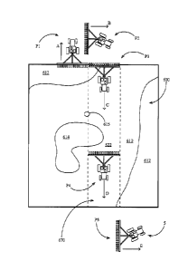
[0026] Referring again to FIG. 7, at step 115 the planter 10 preferably begins
planting a according to
the prescription map 300. Turning to FIG. 5, the planter 10 is illustrated
planting a field 600.
Regions 602 within the field 600 correspond to regions 302 in the prescription
map 300 having like
suffixes (see FIG. 3). Thus, as the planter traverses the field 600, the
monitor 50 preferably uses a
signal generated by the GPS receiver 52 to determine the location of each row
unit 16 and
commands the drive 427 associated with each row unit 16 to plant at the
application rate associated
with the prescription map region 302 corresponding to the field region 602 in
which the row unit 16
is located. By way of example, at the position of the planter 10 in FIG. 5,
the monitor 50 preferably
determines that the row unit 16-1 is in the field region 602-3 corresponding
to the prescription map
region 302-3, and thus commands the drive 427 associated with the row unit 16-
1 to plant at
application rate 310 (e.g., 30,000 seeds per acre).
[0027] Returning to FIG. 7, at step 120 the monitor 50 preferably determines
whether the planter 10
has crossed a field marker location 615 corresponding to the location of the
marker 51 placed on the
prescription map 300 (e.g., by determining whether a non-zero union exists
between the marker
location and a rectangle having a width scaled to the width of the toolbar 14
and centered on a
transverse centerline of the tractor 5). In some embodiments, at step 120 the
monitor 50 determines
whether the GPS receiver 52 (or the planter 10) is within a threshold distance
of the marker 515.
[0028] Once the planter 10 has crossed the field marker location 615, at step
125 the monitor 50
preferably determines whether the planter 10 has begun a new pass, preferably
by determining
whether one or more new pass conditions have been met according to a process
200 described herein
with respect to FIG. 8. In FIG. 5, the planter is illustrated crossing the
marker location 615; in FIG.
6, the planter is illustrated executing a turn outside the field at a position
P2 and beginning a new
pass at a position P3.
[0029] Referring again to FIG. 7, once the planter 10 has begun a new pass
after crossing the marker
location 615, at step 130 the monitor 50 preferably commands the drives 427 to
plant at the plot
application rate 522. At step 132 the monitor 50 preferably records the GPS
vertices of the plot area
670 while planting the plot area 670, e.g., by recording the area passed over
by the toolbar 14 within
the field 600. At step 135, the monitor 50 preferably determines whether the
pass has been
completed, preferably by determining whether one or more plot completion
conditions have been
CA 2894568 2019-03-14
met according to a process 250 described herein with respect to FIG. 9. In
other embodiments, step
135 is carried out using the same process 200 used to determine whether a new
pass has begun.
[0030] Turning to FIG. 6, as the pass is completed the planter 10 plants a
plot area 670 at the plot
application rate 522. It should be appreciated that in planting at the plot
application rate 522 within
the plot area 670, the monitor 50 disregards the prescription map 300.
[0031] Once the pass has been completed at step 135, the monitor 50 preferably
stops recording the
plot area at step 137 and preferably resumes planting according to the
prescription map 300 at step
140. At step 145, the monitor 50 preferably displays an as-planted
prescription map 300', e.g., on an
as-planted prescription screen 500 as illustrated in FIG. 10. The as-planted
prescription map 300'
includes a plot area 570 corresponding to the plot area 670 planted at the
plot application rate 522. It
should be appreciated that the plot area 570 includes locations that were
occupied by other regions
302 in the original prescription map 300.
[0032] A preferred process 200 for determining whether a new pass has begun is
illustrated in FIG.
8. At step 205, the monitor 50 determines whether the planter 10 is seeding,
preferably by
determining whether a seed pulse has been received over a threshold period
from any of the seed
sensors 420 associated with the row units 16. If the planter 10 is seeding,
then at step 210 the
monitor 50 preferably records the planter direction. Where a direction of the
planter is determined
herein, this step is preferably accomplished by comparing sequential positions
reported by the GPS
receiver 52; it should be appreciated that the orientation of the planter is
most easily determined if
the GPS receiver 52 is mounted to the planter (e.g., on the toolbar 14), but
in embodiments in which
the GPS receiver 52 is mounted to the tractor, the monitor 50 preferably
either assumes the planter
direction is equal to the tractor direction or estimates a planter direction
based on the tractor path. At
step 215, the monitor 50 preferably determines whether the planter has stopped
seeding; this step is
preferably carried out similarly to step 205 but with opposite logic. Once the
planter has stopped
seeding, at step 220 the monitor 50 preferably records the last recorded
planter direction while the
planter was seeding (e.g., direction A of the planter at position P1 in FIG.
6). In some embodiments,
the last recorded planter direction recorded at step 220 comprises an average
value recorded over a
predetermined distance (e.g., 35 feet) or during a predetermined time (e.g., 5
seconds) prior to the
time at which the planter stopped seeding.
[0033] Continuing to refer to FIG. 8, at step 222 the monitor 50 preferably
determines whether the
planter is in a lifted position. Where the monitor 50 determines raised or
lowered position of the
planter herein, this step is preferably accomplished by comparing a signal
generated by the lift
sensor 422 to a threshold signal; in other embodiments, the monitor 50
commands one or more
6
CA 2894568 2019-03-14
actuators to raise or lower the planter and determines that the planter has
been raised or lowered,
respectively, immediately after the command has been sent or after a threshold
delay after the
command has been sent. Once the planter has been lifted, at step 225 the
monitor 50 preferably
determines whether the planter has been lowered, preferably by a process
similar to step 222 but
with opposite logic. Once the planter has been lowered, at step 227 the
monitor 50 preferably begins
to monitor a direction change representing the difference (e.g., in degrees)
between the current
planter direction (e.g., direction B at position P2 in FIG. 6) and the first
direction stored at step 220
(e.g., direction A at position P1 in FIG. 6). At step 230, the monitor 50
preferably determines
whether the direction change exceeds a threshold (e.g., 150 degrees). Once the
direction change has
exceeded the threshold, at step 235 the monitor 50 preferably determines that
a new pass has been
started, e.g., by storing a value used by process 10010 determine that a new
pass condition has been
met at step 125
[0034] A preferred process 250 for determining whether a pass has been
completed is illustrated in
FIG. 9. At step 255, the monitor 50 determines whether the planter 10 has been
seeding over a
threshold distance, preferably by storing a time period bounded by a first
time and a second time
during which the planter is seeding and comparing a first position reported by
the GPS receiver 52 at
the first time to a second position reported by the GPS receiver at the second
time. In some
embodiments the threshold distance used in step 255 comprises a value pm-
loaded in memory of the
monitor 50 or entered by the user after placing the marker 515. In other
embodiments, the monitor
50 determines the threshold distance by determining the likely planter
direction when crossing the
marker 515 (e.g., using a user-provided indication of likely direction or by
accessing a file of
recorded GPS coordinates recorded during prior field operations) and then
measures a distance
between the marker 515 and a field boundary or inner headland boundary along
the determined
likely planter direction. If the planter 10 has been seeding over the
threshold distance, then at step
260 the monitor 50 preferably confirms that the planter is still seeding. If
the planter is still seeding,
then at step 265 the monitor 50 preferably records the planter direction
(e.g., direction D at position
P4 in FIG. 6). At step 270, the monitor 50 preferably determines whether the
planter has stopped
seeding; this step is preferably carried out similarly to step 260 but with
opposite logic. Once the
planter has stopped seeding, at step 275 the monitor 50 preferably determines
whether the planter is
in a lifted position.
[0035] Continuing to refer to FIG. 9, once the planter has been lifted, at
step 280 the monitor 50
preferably determines and records a first direction equal to the last recorded
planter direction while
the planter was seeding. At step 282, the monitor 50 preferably determines
whether the planter is in
a lowered position. If the planter is lowered, at step 285 the monitor 50
preferably begins to monitor
a direction change representing the difference (e.g., in degrees) between the
current planter direction
7
CA 2894568 2019-03-14
(e.g., direction E at position P5 in FIG. 6) and the first direction stored at
step 275. At step 290, the
monitor 50 preferably determines whether the direction change exceeds a
threshold (e.g., 100
degrees). Once the direction change has exceeded a threshold, at step 295 the
monitor 50 preferably
determines that a pass has been completed, e.g., by storing a value used by
process 100 to determine
that a pass completion condition has been met at step 135.
[0036] Referring to FIGs. 11 and 12, an alternative method of placing a plot
based on a marker
location is illustrated and described. As illustrated in FIG. 11, the user
typically plants one or more
headlands 360 around the perimeter of the field before planting the remainder
of the field. Because
the headland 360 is planted by a circumferential pass around the perimeter of
the field, the headland
has an inner boundary 364 separated from the field boundary 304 by the planter
width Wp. The user
preferably enters the planter width Wp into the memory of the monitor 50
during a setup phase. As
illustrated, the monitor preferably displays an estimated headland inner
boundary 364 based on the
planter width Wp.
[0037] Turning to FIG. 12, a process 800 for placing a plot based on the
distance from a marker to a
headland is illustrated. At step 805, the monitor 50 preferably prompts and
enables the user to place
the marker 515 on the prescription map 300 as described above. At step 807,
the monitor 50
preferably determines a set of distances from the marker 515 to the headland
inner boundary 364
along a set of planting directions. By way of example, FIG. 11 illustrates a
first distance Dh-1 along
a first direction P1 and a second distance Dh-2 along a second direction P2.
At step 810, the monitor
50 preferably prompts and enables the user to enter a plot application rate as
described above. At
step 815, the user preferably begins planting and the monitor 50 commands
planting rates according
to the prescription map 300. At step 820, the monitor 50 preferably determines
whether the planter
has crossed the location of the marker 515. If the planter 10 has crossed the
location of the
marker 515, at step 822 the monitor preferably determines the planter
direction and at step 823
determines whether the implement has traveled a minimum distance that was
associated with that
direction at step 807. Once the planter has traveled the minimum distance, at
step 825 the monitor
50 preferably determines whether a new pass condition has been met, preferably
using the process
described herein with respect to FIG. 8. Once a new pass has been begun, at
step 830 the monitor 50
preferably begins planting at the plot application rate and at step 832
records the area covered while
planting at the plot application rate. At step 835, the monitor 50 preferably
determines whether a
pass completion condition has been met, preferably using the process described
herein with respect
to FIG. 9. Once a pass completion condition step has been met, at step 837 the
monitor preferably
stops recording the plot area and at step 840 resumes planting according to
the prescription map 300.
At stop 845 the monitor 50 preferably displays the recorded plot area on an as-
applied map as
described herein with respect to FIG. 10.
8
CA 2894568 2019-03-14
[0038] Turning to FIG. 13, an alternative process 800' similar to the process
800 is illustrated. At
step 806, the monitor 50 preferably determines a likely direction of the
planter 10 when crossing the
marker 515 (e.g., using a user-provided indication of likely direction or by
accessing a file of
recorded GPS coordinates recorded during prior field operations). At modified
step 807', the monitor
50 preferably determines a threshold distance based on the likely planter
direction. It should be
appreciated that determining the planting direction is unnecessary in process
800. At modified step
823', the monitor 50 determines whether the implement has traveled the
threshold distance. It should
be appreciated that like-numbered steps of process 800' are substantially
similar to the steps
described herein with respect to process 800.
[0039] Although the systems and methods disclosed herein are illustrated and
described with respect
to the rate at which seeds are planted, in other embodiments the same systems
and methods are be
applied to other crop inputs applied using variable application implements
other than planters. For
example, in some embodiments the rate at which liquid fertilizer is applied
using a variable rate
application system is varied and the resulting yields are obtained after
harvesting using the methods
presented herein. In other embodiments, a system for planting different seed
varieties during
planting could be used to plant plots of different varieties using the methods
presented herein.
[0040] The foregoing description is presented to enable one of ordinary skill
in the art to make and
use the invention and is provided in the context of a patent application and
its requirements. Various
modifications to the preferred embodiment of the apparatus, and the general
principles and features
of the system and methods described herein will be readily apparent to those
of skill in the art. Thus,
the present invention is not to be limited to the embodiments of the
apparatus, system and methods
described above and illustrated in the drawing figures, but is to be accorded
the widest scope
consistent with the scope of the appended claims.
9
CA 2894568 2019-03-14